The Future of Oilfield Progress Tracking: Virtual Tours in Action

Cloudpano
July 26, 2025
5 min read
Share this post

🛢️ The Future of Oilfield Progress Tracking: Virtual Tours in Action 🚀🎥

Tracking progress across sprawling oilfield sites has always been a logistical challenge. With multiple teams, remote locations, and strict compliance demands, staying informed in real time isn’t just convenient — it’s mission-critical.

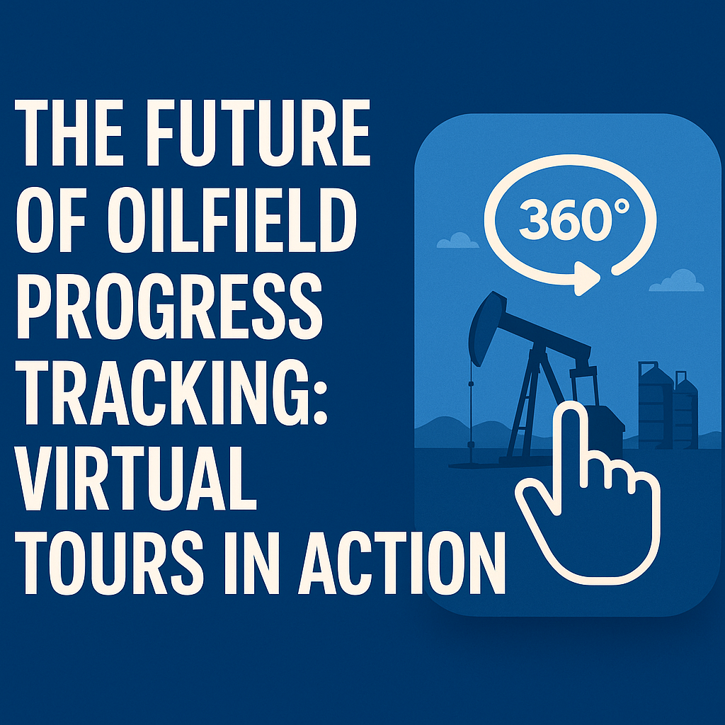
Enter 360° virtual tours — the future of oilfield progress tracking. 🌐🔍

This guide explores how operators are using immersive walkthroughs to monitor field development, track project milestones, and share updates across teams — all without setting foot on-site.

⚙️ The Challenges of Traditional Progress Tracking

Before virtual tours, teams relied on:

  • 📸 Flat photos
  • 📝 Field notes
  • 📧 Email updates
  • 🛻 In-person inspections

While these methods worked in the past, they fall short in today’s fast-paced, high-risk environments. Operators often deal with:

  • Delayed updates
  • Inconsistent reporting
  • Communication breakdowns
  • Costly travel for site visibility
  • Missed safety or QA issues

🔗 Related: Cut Site Visits, Not Visibility: 360 Virtual Tours for Oilfields

🌀 What Are Virtual Tours for Oilfields?

A 360° virtual tour is an interactive, panoramic view of a physical space — captured by a 360 camera or drone and hosted online.

It allows users to:

  • 🚶 Walk through the site virtually
  • 🧠 View tagged equipment and infrastructure
  • 📄 Access real-time data overlays and updates
  • 📆 Revisit historical versions for comparison

🔗 Related: Real-Time Oilfield Development Tracking with 360° Virtual Tours

🔍 Why Use Virtual Tours for Progress Monitoring?

📸 1. Visual Milestone Documentation

Capture before-and-after visuals for every phase — from grading to equipment installation to commissioning.

🔗 Related: 360° Virtual Tours for Oilfield Project Updates: A Complete Guide

⏱️ 2. Time-Saving Field Inspections

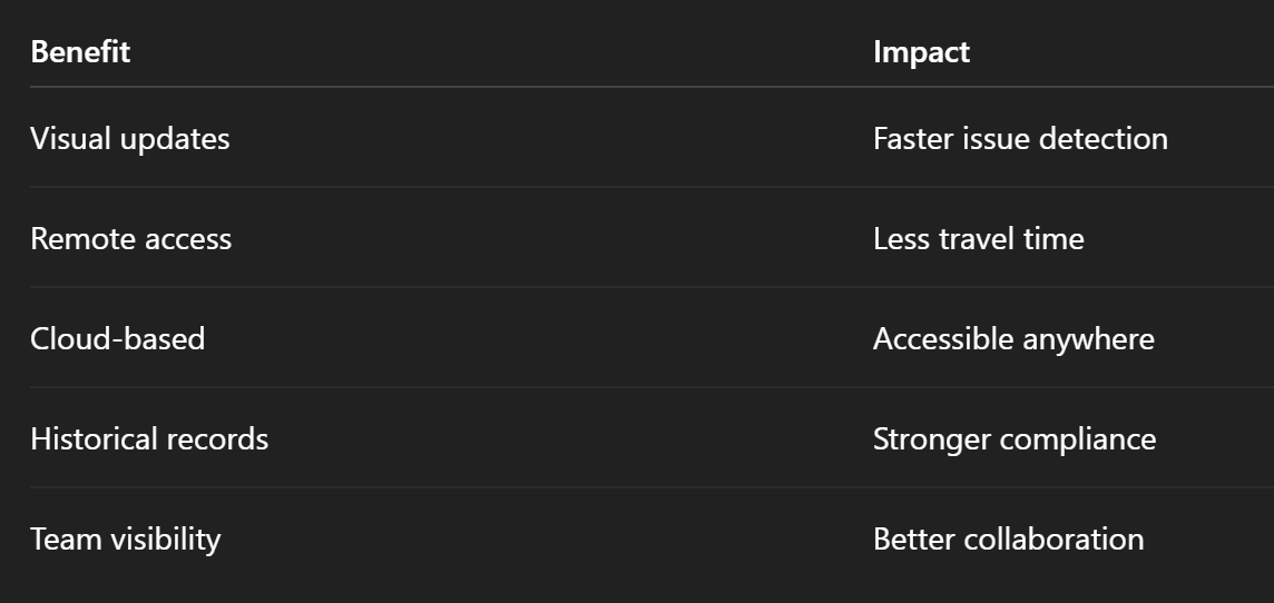
Supervisors and engineers can view daily or weekly updates without leaving the office, saving hours per week in travel.

🔗 Related: Streamlining Oilfield Inspections Using 360 Virtual Tours

📊 3. Transparent Reporting

Virtual tours offer transparent, visual-first documentation to investors, partners, and compliance officers.

🔗 Related: Cloud-Based Oilfield Reporting with Virtual Tours

🧠 4. Better Team Collaboration

Field crews, office staff, and contractors can leave comments, mark issues, or log updates right inside the tour.

🔗 Related: Enhancing Safety with Remote Site Inspections in the Oil and Gas Sector

🧯 5. Real-Time Safety & Compliance Checks

Hotspots in the virtual tour can flag hazards, show PPE zones, and log maintenance records.

🔗 Related: Remote Oilfield Safety Training with 360 VR Technology

🛠️ How to Build a Virtual Progress Tracker

🖼️ Step 1: Capture the Site

Use a 360 camera or drone to document your site weekly or per milestone.

Top gear:

  • Insta360 One RS
  • Ricoh Theta Z1
  • DJI Mavic 3 Enterprise

🔗 Related: Best Cameras and Drones for Oilfield Virtual Tours in 2025

☁️ Step 2: Upload to a Virtual Tour Platform

Use a platform like CloudPano to:

  • Create site walkthroughs
  • Add timestamps and location tags
  • Embed updates and documents
  • Share links securely with your team

🔗 Related: Building a Centralized Oilfield Documentation System with 360 Tours

🔁 Step 3: Repeat and Compare

Schedule recurring captures to track progress over time.

Visual comparisons help teams:

  • Validate contractor progress
  • Document maintenance and fixes
  • Pass audits and meet regulations
  • Spot delays early

📈 Case Study: Progress Tracking in Action

A Midland-based operator used 360° virtual tours to track the construction of a compressor station.

✅ Results in 90 Days:

  • 🔄 Reduced site visits by 60%
  • 📉 Cut travel costs by $18,000
  • 🧯 Identified 3 critical issues remotely
  • 📆 Hit milestones 2 weeks early
  • 🔐 Passed compliance audit using visual tour archives

🔗 Related: Case Study: Virtual Tour Implementation for Oilfield Workflow Visibility

💡 Use Case: Multi-Site Visibility for Executives

Executives and stakeholders often oversee multiple locations. With virtual progress tracking:

  • View any site from a central dashboard
  • Zoom in on project details
  • Track timelines across assets
  • Get weekly visual updates in one click

🔗 Related: Virtual Site Updates: How 360° Virtual Tours Improve Oilfield Oversight

📚 Use Case: Maintenance Verification

Documenting repairs and servicing becomes easier when:

  • Crews tag the location in a 360 tour
  • Supervisors verify the fix remotely
  • Photos and documents are embedded in the scene

No more email chains or missed issues.

🔐 Use Case: Audit Trail and Compliance

360° virtual tours create a time-stamped, visual record of site conditions and work completed. This simplifies:

  • Environmental reviews
  • Safety inspections
  • Regulatory compliance
  • Third-party reporting

🔗 Related: Revolutionize Oilfield Reporting with 360-Degree Virtual Walkthroughs

✅ Summary: Why Virtual Tours Are the Future of Oilfield Tracking

Virtual tours aren’t just about cool tech — they’re about better management, fewer delays, and smarter decisions.

🚀 Ready to Modernize Your Progress Tracking?

Here’s your quick-start checklist:

  1. Choose a 360 camera or drone
  2. Pick a cloud platform like CloudPano
  3. Capture weekly site updates
  4. Tag milestones, repairs, and notes
  5. Share progress across your team and stakeholders

You’ll get more clarity, save more time, and keep projects on schedule — all while building a smarter, visual-first oilfield operation. 💡🛢️

Share this post
Cloudpano

Choose The Right 360° Camera

Insta360 ONE RS 1-Inch 360 Edition

  • Compact, ready to go anywhere

  • Interchangeable lens that’s upgradeable

  • Dual 1-inch sensors for improved clarity and low light performance

  • Dynamic range and 6K 360° capture

  • 360° photo resolution at 21MP

Learn More

Insta360 X4

  • 8K 360° video recording for ultra-detailed visuals.

  • 4K single-lens mode for traditional wide-angle shots.

  • Invisible selfie stick effect for drone-like perspectives.

  • 2.5-inch touchscreen with Gorilla Glass protection.

  • Waterproof up to 33ft for underwater shooting.

Learn More

Ricoh Theta Z1

  • 360° photo resolution in 23MP

  • Slim design at 24 mm thick

  • Built-in image stabilization for smooth video capture.

  • Internal 19GB storage for photo and video storage.

  • Wireless connectivity for remote control and sharing.

Learn More

Ricoh Theta X

  • 60MP 360° still images for high-resolution photography.

  • 5.7K 360° video recording at 30fps.

  • 2.25-inch touchscreen for intuitive control.

  • USB Type-C port for fast charging and data transfer.

  • MicroSD card slot for expandable storage.

Learn More
Property Marketing
Allows potential buyers to explore properties in detail from anywhere, enhancing the real estate marketing process.
Automotive Spins
Create an interactive virtual showroom and engage affluent digital buyers with live 360º video calls, all through the CloudPano mobile app for a complete automotive sales solution.
Interactive Floor Plans
Create 2D and 3D floor plans with measurements in 4 minutes or less, all from your phone. Download the Floor Plan Scanner app and get your first scan free.

360 Virtual Tours With CloudPano.com. Get Started Today.

Try it free. No credit card required. Instant set-up.

Try it free
Latest posts

See our other posts

Interviews, tips, guides, industry best practices, and news.

Mastering Compliance: The Future of Automated Property Video

This article provides a definitive guide for real estate professionals on navigating strict MLS branding regulations through AI-driven automation. It addresses the risks of compliance violations, details the limitations of manual editing workflows, and introduces a scalable, "compliance-first" system for generating high-quality, MLS-approved property videos. The post serves as a strategic blueprint for agents aiming to maintain listing visibility, avoid regulatory penalties, and streamline their marketing operations.
Read post

Future-Proofing Your Business with MLS Safe AI Video for Listings

This high-authority guide focuses on long-term operational stability and the strategic advantages of leveraging artificial intelligence to bypass the industry-wide friction between high-impact marketing and regulatory compliance. Key Takeaways & Content Structure: The Reputation-Risk Factor: Explains the high cost of compliance errors, focusing on how a single technical oversight—such as a misplaced logo or branded watermark—can trigger a systemic board audit, leading to immediate listing suspension and lasting reputational damage with sellers. The Production Disconnect: Breaks down the "two-version" operational tax, where marketing teams suffer from repetitive rendering, file-management bloat, and the persistent danger of human error when manually managing branded vs. unbranded media assets. AI as a Compliance Engine: Defines how advanced AI media platforms move beyond mere aesthetics to function as regulatory safeguards. It illustrates the technical architecture where the AI engine isolates branding data from structural property data at the rendering level, effectively "forking" the output into two distinct, safe-to-use tracks. Operational Blueprint: Maps out a transparent, 6-step automation funnel that takes a listing from flat photograph ingestion to syndicate-ready, neutral-hosted media in minutes. Strategic Scalability: Demonstrates why centralizing production into a single SaaS platform is the only way for growing brokerages to maintain consistency, remove contractor-level liability, and recover significant administrative time. The PhotoAIVideo.com Edge: Concludes by positioning the platform as a purpose-built solution that combines high-definition parallax AI motion with an automated "compliance-first" export workflow, ensuring Realtors can generate professional, engaging video content that passes even the most stringent board audits on the first attempt.
Read post

Streamlining Your Workflow with a Specialized MLS Compliant Real Estate Media App

This article functions as a tactical operations guide for real estate marketers and brokerage leaders focused on reducing technical friction and human error in their media publishing pipeline. Key Takeaways & Content Structure: The "Stop-Work" Order: Addresses the high-stakes reality of MLS compliance flags, where automated rules block properties from IDX feeds due to accidental branding, causing immediate listing velocity loss. The Fragmented Workflow Problem: Identifies the "manual bottleneck"—the inefficiency of having field photographers deliver single assets that then require internal staff to manually strip, re-render, and verify separate branded and unbranded versions. Architecture of Dual-Path Rendering: Illustrates the technological shift toward programmatic asset management. It explains how a modern app processes a single source file into two isolated rendering tracks: a lead-gen-heavy marketing track and a strictly compliant, unbranded track for MLS syndication. Operational Workflow Mapping: Provides a clear, 6-step blueprint for moving from raw photography ingestion to compliant deployment, including automated motion application, metadata scrubbing, and neutral link hosting. Risk Mitigation for Brokerages: Highlights how centralized management dashboards eliminate the "wild west" of agent-led media creation, providing brokers with a single-pane-of-glass view to ensure compliance across all active listings. The PhotoAIVideo.com Advantage: Positions the platform as the ideal MLS compliant real estate media app that leverages AI to inject cinematic motion into flat listing photos, effectively automating the entire compliance-forking process and increasing overall production capacity by up to 94%.
Read post