Revolutionize Oilfield Reporting with 360-Degree Virtual Walkthroughs

Cloudpano
July 25, 2025
5 min read
Share this post

🛢️ Revolutionize Oilfield Reporting with 360-Degree Virtual Walkthroughs 🛰️📋

Oilfield reporting has come a long way from clipboards and spreadsheets. In today’s fast-paced, high-risk environments, teams need real-time, visual, and collaborative documentation tools — not static data buried in PDFs. That’s where 360-degree virtual walkthroughs come in. 🌀👷‍♀️

In this post, we’ll explore how 360° virtual tours are transforming the way oil and gas teams report, communicate, and manage field operations — from compliance audits to investor updates.

📉 The Problem with Traditional Oilfield Reporting

If you're still relying on old-school methods like field notes, manual photos, and Word docs, you're probably running into these issues:

  • 🕰️ Delayed updates and missed milestones
  • 🔍 Limited context with static photos
  • 📤 Disconnected reports across departments
  • 👷 Inability to verify field conditions remotely
  • 📎 Documentation that’s hard to access and organize

🔗 Related: Cloud-Based Oilfield Reporting with Virtual Tours

🎥 What Are 360-Degree Virtual Walkthroughs?

A 360° virtual walkthrough is a digital representation of a physical oilfield site, captured with panoramic cameras or drones and hosted online.

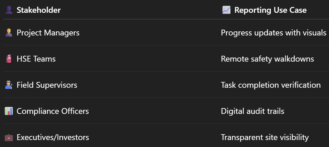
With these immersive walkthroughs, stakeholders can:

  • 🚶 "Walk" the site from any device
  • 🔖 Click on interactive hotspots with annotations
  • 🗂️ View tagged assets and inspection records
  • 🕒 Revisit historical data in visual format

🔗 Related: 360° Virtual Tours for Oilfield Project Updates: A Complete Guide

🚀 How 360 Virtual Walkthroughs Improve Reporting

1️⃣ Visual-First Reporting

Replace long, text-heavy updates with interactive visuals that speak for themselves.

  • Zoom in on equipment
  • Click hotspots to view documentation
  • Compare "before and after" conditions

🔗 Related: From Ground to Cloud: Tracking Oilfield Workflows with 360 Virtual Tours

2️⃣ Real-Time Access for Stakeholders

Share a secure link with engineers, executives, or clients — so they can explore updates without stepping on-site.

  • 🧑‍💼 No site travel required
  • 📆 More frequent updates
  • ✅ Better visibility and transparency

🔗 Related: Virtual Site Updates: How 360° Virtual Tours Improve Oilfield Oversight

3️⃣ Faster Decision-Making

Instead of flipping through photos or emailing questions, decision-makers can see what’s happening and respond instantly.

  • Fewer delays
  • Streamlined approvals
  • Immediate feedback loops

4️⃣ Centralized Documentation Hub

Platforms like CloudPano enable teams to:

  • Organize walkthroughs by site or project
  • Archive versions for audits
  • Attach SOPs, compliance docs, and vendor notes

🔗 Related: Building a Centralized Oilfield Documentation System with 360 Tours

🛠️ Setting Up a 360° Reporting Workflow

🖼️ Step 1: Capture the Site

Use a 360 camera or drone to capture immersive views of key areas:

  • Well pads
  • Tank batteries
  • Pipeline crossings
  • Modular buildings
  • HSE zones

Recommended tools:

  • Insta360 One RS
  • Ricoh Theta Z1
  • DJI Mavic 3 Enterprise

🔗 Related: Best Cameras and Drones for Oilfield Virtual Tours in 2025

☁️ Step 2: Upload to a Cloud Platform

Platforms like CloudPano let you:

  • Upload multiple scenes
  • Embed PDFs, images, or videos
  • Add callouts for tasks or hazards
  • Create shareable links with permissions

🔁 Step 3: Publish and Repeat

Schedule recurring walkthroughs (weekly, monthly, or milestone-based) to build a living record of your operations.

  • Save all versions
  • Compare progress visually
  • Show audit trails for regulators

🔗 Related: Real-Time Oilfield Development Tracking with 360° Virtual Tours

🧾 Use Cases Across the Industry

🔗 Related: Streamlining Oilfield Inspections Using 360 Virtual Tours

📚 Case Study Highlight

A Permian Basin operator implemented 360° walkthroughs for weekly progress updates across 9 sites. Their results:

  • 🔄 Reduced in-person site visits by 70%
  • 📉 Lowered reporting errors by 45%
  • ⏱️ Cut approval cycles by 3 days
  • 🔐 Improved documentation retention for audits

🔗 Related: Case Study: Virtual Tour Implementation for Oilfield Workflow Visibility

🔐 Safety & Training Included

Beyond reporting, these walkthroughs double as:

  • 🎓 Onboarding tools for new hires
  • 🛡️ Visual safety training for hazard identification
  • 📍 Location-based SOP delivery

🔗 Related: Remote Oilfield Safety Training with 360 VR Technology

✅ Why This Matters in 2025 and Beyond

Modern oilfield operations are too dynamic for slow, outdated reporting systems.

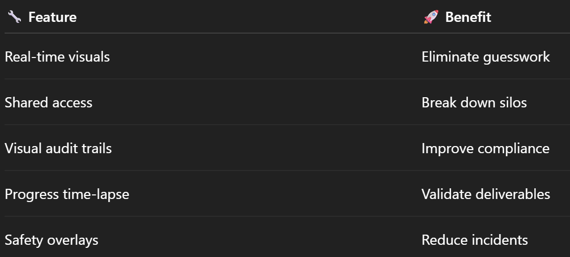
With 360° virtual walkthroughs, teams benefit from:

📦 Bonus: Combine With Other Technologies

Pair 360° walkthroughs with:

  • 🛩️ Drone flyovers
  • 🧠 AI-based defect detection
  • 📱 QR codes for field access
  • 💬 Collaborative comments for task tracking

🔗 Related: Monitor Oilfield Progress Remotely with Interactive 360 Technology

🏁 Final Thoughts: A Smarter Way to Report

In 2025, your reporting should work for you, not against you.

By adopting 360-degree virtual walkthroughs, you can:

✅ Save time
✅ Increase clarity
✅ Enhance safety
✅ Reduce risk
✅ Keep stakeholders aligned

📩 Ready to transform your oilfield reporting process?

Let 360° tech lead the way. Your team — and your bottom line — will thank you. 💡📈

Share this post
Cloudpano

Choose The Right 360° Camera

Insta360 ONE RS 1-Inch 360 Edition

  • Compact, ready to go anywhere

  • Interchangeable lens that’s upgradeable

  • Dual 1-inch sensors for improved clarity and low light performance

  • Dynamic range and 6K 360° capture

  • 360° photo resolution at 21MP

Learn More

Insta360 X4

  • 8K 360° video recording for ultra-detailed visuals.

  • 4K single-lens mode for traditional wide-angle shots.

  • Invisible selfie stick effect for drone-like perspectives.

  • 2.5-inch touchscreen with Gorilla Glass protection.

  • Waterproof up to 33ft for underwater shooting.

Learn More

Ricoh Theta Z1

  • 360° photo resolution in 23MP

  • Slim design at 24 mm thick

  • Built-in image stabilization for smooth video capture.

  • Internal 19GB storage for photo and video storage.

  • Wireless connectivity for remote control and sharing.

Learn More

Ricoh Theta X

  • 60MP 360° still images for high-resolution photography.

  • 5.7K 360° video recording at 30fps.

  • 2.25-inch touchscreen for intuitive control.

  • USB Type-C port for fast charging and data transfer.

  • MicroSD card slot for expandable storage.

Learn More
Property Marketing
Allows potential buyers to explore properties in detail from anywhere, enhancing the real estate marketing process.
Automotive Spins
Create an interactive virtual showroom and engage affluent digital buyers with live 360º video calls, all through the CloudPano mobile app for a complete automotive sales solution.
Interactive Floor Plans
Create 2D and 3D floor plans with measurements in 4 minutes or less, all from your phone. Download the Floor Plan Scanner app and get your first scan free.

360 Virtual Tours With CloudPano.com. Get Started Today.

Try it free. No credit card required. Instant set-up.

Try it free
Latest posts

See our other posts

Interviews, tips, guides, industry best practices, and news.

CloudPano 360 Measuring Tool Tutorial — Take Off Floor & Wall Quantities Easily

This tutorial walks readers through using CloudPano’s 360° Measuring Tool to quickly and accurately take off floor areas, wall surfaces, and room dimensions. The guide explains how to calibrate a 360 panorama, measure straight lines, surfaces, and complex shapes, and export professional documentation for estimating, insurance claims, restoration, and renovation planning. With pro accuracy tips and real-world use cases, the article shows how CloudPano simplifies takeoffs for contractors, adjusters, property managers, and real estate professionals.
Read post

How to Use CloudPano’s 360 Measuring Software to Measure Floors and Walls

This guide teaches readers how to use CloudPano’s 360° Measuring Software to measure floors, walls, and interior surfaces with speed and accuracy. It covers setting up a virtual tour, calibrating a known measurement, taking linear, area, and vertical measurements, and exporting reports. The article also highlights best practices for accuracy, industry use cases, and how 360° measurement simplifies takeoffs for contractors, insurance adjusters, property managers, and restoration professionals.
Read post

Step-by-Step Guide: Using CloudPano’s 360 Measuring Tool for Accurate Takeoffs

This guide explains how to use CloudPano’s 360° Measuring Tool to complete fast and accurate takeoffs for construction, insurance, restoration, and property management. Readers learn how to calibrate a 360° panorama, measure walls, floors, and room dimensions, and export professional documentation. The post also highlights best practices for accuracy, real-world applications across multiple industries, and how remote 360° measuring saves time while improving estimating and reporting workflows.
Read post