Smarter Oilfield Management Starts with 360 Virtual Documentation

July 25, 2025
5 min read
Share this post

🛢️ Smarter Oilfield Management Starts with 360° Virtual Documentation 📸🧠

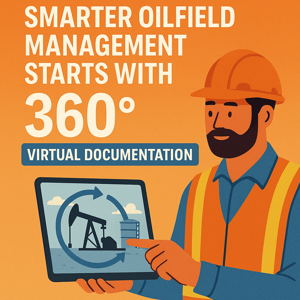
Managing oilfield operations in 2025 is more complex than ever — sprawling infrastructure, tight timelines, and rising safety demands all make real-time decision-making essential. But traditional documentation methods can’t keep up.

That’s where 360° virtual documentation comes in. By capturing oilfield assets and workflows with interactive, cloud-based visuals, teams gain instant access to everything they need — without stepping on-site. 🚁💻

This guide will show you how to implement 360° documentation to cut costs, streamline inspections, and boost visibility across your operations.

⚠️ The Limitations of Traditional Oilfield Documentation

Here’s what many oil and gas teams are still dealing with:

  • 🧾 Disorganized photos and paperwork
  • 📤 Email chains and siloed spreadsheets
  • 📍 Inconsistent site records
  • 🔍 Missed safety issues or maintenance delays
  • 🧑‍💼 Time-consuming compliance checks

🔗 Related: Cloud-Based Oilfield Reporting with Virtual Tours

🌐 What is 360° Virtual Documentation?

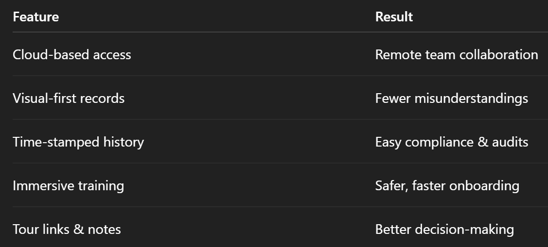
360° virtual documentation uses panoramic images or drone-captured visuals to build interactive, explorable records of your job sites, assets, and infrastructure. Key features include:

  • 🌀 Full-room or aerial capture
  • 📌 Clickable “hotspots” with annotations
  • 🗂️ Embedded SOPs, PDFs, or safety info
  • 🕒 Time-stamped updates and version control
  • 🌍 Cloud-based access for any stakeholder

🔗 Related: Building a Centralized Oilfield Documentation System with 360 Tours

🎯 Benefits of 360° Documentation for Oilfield Management

✅ 1. Centralized, Searchable Site Records

Forget buried PDFs and chaotic photo folders — 360° platforms give you a single source of truth with visual clarity.

✅ 2. Remote Oversight

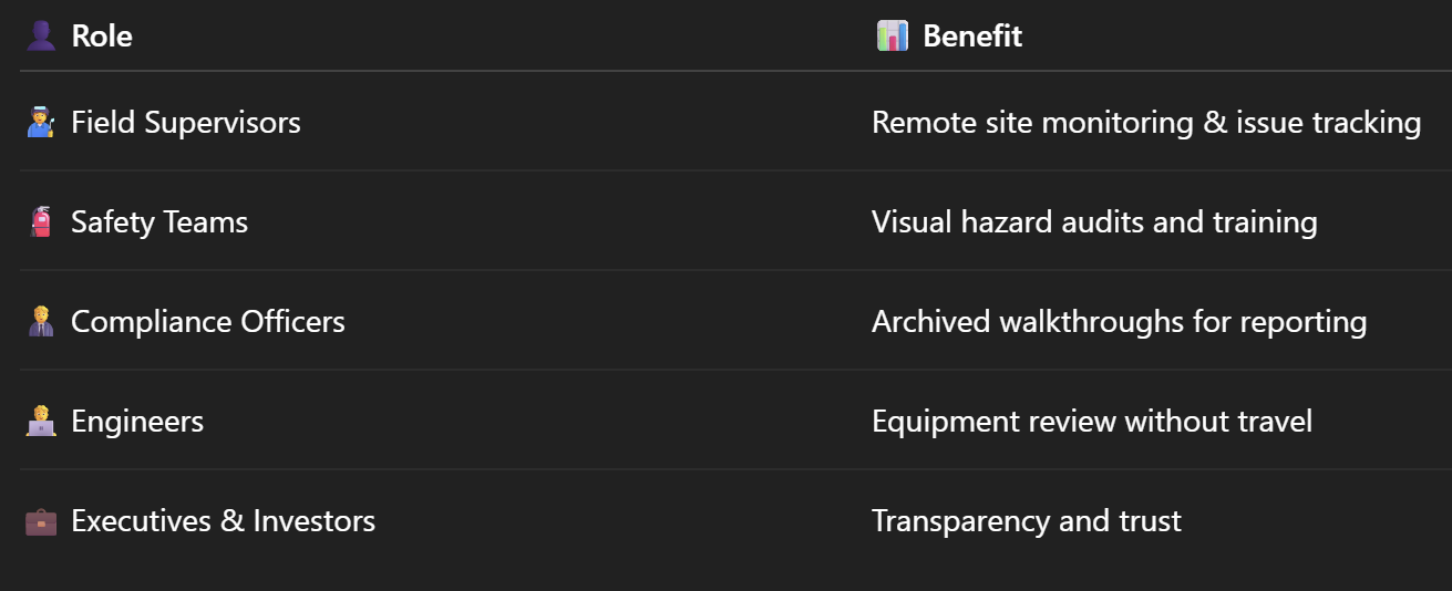
From executives to engineers, everyone can view and explore oilfield conditions in real time — from any device. No boots on the ground required. 👞🚫

🔗 Related: Cut Site Visits, Not Visibility: 360 Virtual Tours for Oilfields

✅ 3. Visual Audit Trail

360° walkthroughs are time-stamped and stored securely, creating a verifiable visual record for inspections, maintenance, and regulatory compliance.

🔗 Related: Virtual Site Updates: How 360° Virtual Tours Improve Oilfield Oversight

✅ 4. Accelerated Training & Safety

New hires can train using immersive site walkthroughs before arriving in the field, reducing risks and onboarding time. 📚🦺

🔗 Related: Remote Oilfield Safety Training with 360 VR Technology

✅ 5. Faster Decision-Making

Why wait for inspection reports when you can visually verify asset status, safety conditions, or progress instantly?

🔗 Related: Monitor Oilfield Progress Remotely with Interactive 360 Technology

🛠️ How to Implement 360° Virtual Documentation

📷 Step 1: Capture the Site

Use a 360° camera or drone to document the area.

Top tools:

  • Insta360 One RS – great for walkthroughs
  • Ricoh Theta Z1 – ideal for tight spaces
  • DJI Mavic 3 Enterprise – perfect for aerial shots

🔗 Related: Best Cameras and Drones for Oilfield Virtual Tours in 2025

🌐 Step 2: Upload to a Virtual Tour Platform

Upload your visuals to a cloud-based platform like CloudPano, where you can:

  • Create a navigable site map
  • Add hotspots and multimedia
  • Organize scenes by location, asset, or date
  • Control user permissions

🔁 Step 3: Schedule Regular Updates

Capture sites weekly, monthly, or per milestone to build a historical timeline of progress, repairs, or safety issues.

🔗 Related: Real-Time Oilfield Development Tracking with 360° Virtual Tours

📤 Step 4: Share with Your Team

Distribute tour links to:

  • Field supervisors
  • Safety officers
  • Compliance teams
  • Investors or clients

Give them visibility without the travel.

🧪 Real-World Results

A South Texas operator managing 12 well pads across 3 counties implemented 360° virtual documentation for maintenance and compliance.

📈 After 90 days:

  • 🛠️ Reduced travel time for inspections by 68%
  • 🧾 Decreased paperwork backlog by 75%
  • 🧯 Caught and resolved 6 safety issues before they escalated
  • 🔐 Passed state audit with zero discrepancies using visual records

🔗 Related: Case Study: Virtual Tour Implementation for Oilfield Workflow Visibility

💼 Who Benefits from 360° Oilfield Documentation?

🔗 Related: Streamlining Oilfield Inspections Using 360 Virtual Tours

📚 Expand Your Digital Oilfield Toolkit

Pair 360° documentation with:

  • 🧠 AI-powered defect detection
  • 📱 QR codes for in-field access
  • 🛰️ Satellite overlays and drone flyovers
  • 💬 Comment-based task collaboration

🔗 Related: Enhancing Oil Rig Safety: VR Safety Induction Virtual Tours Explained

✅ Summary: Why Smart Oilfield Teams Use 360°

🚀 Ready to Get Started?

Here’s your quick launch checklist:

✅ Choose a 360° camera or drone
✅ Select your virtual tour platform
✅ Capture and upload your oilfield scenes
✅ Add annotations and hotspot data
✅ Share with your team for smarter decision-making

Start managing your oilfield assets with clarity and confidence — powered by 360° visual documentation. 🧠🛢️

Share this post

Choose The Right 360° Camera

Insta360 ONE RS 1-Inch 360 Edition

  • Compact, ready to go anywhere

  • Interchangeable lens that’s upgradeable

  • Dual 1-inch sensors for improved clarity and low light performance

  • Dynamic range and 6K 360° capture

  • 360° photo resolution at 21MP

Learn More

Insta360 X4

  • 8K 360° video recording for ultra-detailed visuals.

  • 4K single-lens mode for traditional wide-angle shots.

  • Invisible selfie stick effect for drone-like perspectives.

  • 2.5-inch touchscreen with Gorilla Glass protection.

  • Waterproof up to 33ft for underwater shooting.

Learn More

Ricoh Theta Z1

  • 360° photo resolution in 23MP

  • Slim design at 24 mm thick

  • Built-in image stabilization for smooth video capture.

  • Internal 19GB storage for photo and video storage.

  • Wireless connectivity for remote control and sharing.

Learn More

Ricoh Theta X

  • 60MP 360° still images for high-resolution photography.

  • 5.7K 360° video recording at 30fps.

  • 2.25-inch touchscreen for intuitive control.

  • USB Type-C port for fast charging and data transfer.

  • MicroSD card slot for expandable storage.

Learn More
Property Marketing
Allows potential buyers to explore properties in detail from anywhere, enhancing the real estate marketing process.
Automotive Spins
Create an interactive virtual showroom and engage affluent digital buyers with live 360º video calls, all through the CloudPano mobile app for a complete automotive sales solution.
Interactive Floor Plans
Create 2D and 3D floor plans with measurements in 4 minutes or less, all from your phone. Download the Floor Plan Scanner app and get your first scan free.

360 Virtual Tours With CloudPano.com. Get Started Today.

Try it free. No credit card required. Instant set-up.

Try it free
Latest posts

See our other posts

Interviews, tips, guides, industry best practices, and news.

Mastering Compliance: The Future of Automated Property Video

This article provides a definitive guide for real estate professionals on navigating strict MLS branding regulations through AI-driven automation. It addresses the risks of compliance violations, details the limitations of manual editing workflows, and introduces a scalable, "compliance-first" system for generating high-quality, MLS-approved property videos. The post serves as a strategic blueprint for agents aiming to maintain listing visibility, avoid regulatory penalties, and streamline their marketing operations.
Read post

Future-Proofing Your Business with MLS Safe AI Video for Listings

This high-authority guide focuses on long-term operational stability and the strategic advantages of leveraging artificial intelligence to bypass the industry-wide friction between high-impact marketing and regulatory compliance. Key Takeaways & Content Structure: The Reputation-Risk Factor: Explains the high cost of compliance errors, focusing on how a single technical oversight—such as a misplaced logo or branded watermark—can trigger a systemic board audit, leading to immediate listing suspension and lasting reputational damage with sellers. The Production Disconnect: Breaks down the "two-version" operational tax, where marketing teams suffer from repetitive rendering, file-management bloat, and the persistent danger of human error when manually managing branded vs. unbranded media assets. AI as a Compliance Engine: Defines how advanced AI media platforms move beyond mere aesthetics to function as regulatory safeguards. It illustrates the technical architecture where the AI engine isolates branding data from structural property data at the rendering level, effectively "forking" the output into two distinct, safe-to-use tracks. Operational Blueprint: Maps out a transparent, 6-step automation funnel that takes a listing from flat photograph ingestion to syndicate-ready, neutral-hosted media in minutes. Strategic Scalability: Demonstrates why centralizing production into a single SaaS platform is the only way for growing brokerages to maintain consistency, remove contractor-level liability, and recover significant administrative time. The PhotoAIVideo.com Edge: Concludes by positioning the platform as a purpose-built solution that combines high-definition parallax AI motion with an automated "compliance-first" export workflow, ensuring Realtors can generate professional, engaging video content that passes even the most stringent board audits on the first attempt.
Read post

Streamlining Your Workflow with a Specialized MLS Compliant Real Estate Media App

This article functions as a tactical operations guide for real estate marketers and brokerage leaders focused on reducing technical friction and human error in their media publishing pipeline. Key Takeaways & Content Structure: The "Stop-Work" Order: Addresses the high-stakes reality of MLS compliance flags, where automated rules block properties from IDX feeds due to accidental branding, causing immediate listing velocity loss. The Fragmented Workflow Problem: Identifies the "manual bottleneck"—the inefficiency of having field photographers deliver single assets that then require internal staff to manually strip, re-render, and verify separate branded and unbranded versions. Architecture of Dual-Path Rendering: Illustrates the technological shift toward programmatic asset management. It explains how a modern app processes a single source file into two isolated rendering tracks: a lead-gen-heavy marketing track and a strictly compliant, unbranded track for MLS syndication. Operational Workflow Mapping: Provides a clear, 6-step blueprint for moving from raw photography ingestion to compliant deployment, including automated motion application, metadata scrubbing, and neutral link hosting. Risk Mitigation for Brokerages: Highlights how centralized management dashboards eliminate the "wild west" of agent-led media creation, providing brokers with a single-pane-of-glass view to ensure compliance across all active listings. The PhotoAIVideo.com Advantage: Positions the platform as the ideal MLS compliant real estate media app that leverages AI to inject cinematic motion into flat listing photos, effectively automating the entire compliance-forking process and increasing overall production capacity by up to 94%.
Read post