Top Matterport Alternative for Aerial Drone Virtual Tours

Cloudpano
August 9, 2025
5 min read
Share this post

🚁 Top Matterport Alternative for Aerial Drone Virtual Tours: Why CloudPano Leads the Sky

✈️ Introduction: The Rise of Aerial Virtual Tours

In 2025, aerial drone virtual tours have become a game-changer in real estate, tourism, and construction. They provide potential buyers, investors, or stakeholders with a breathtaking bird’s-eye view of properties, developments, and landscapes — all without stepping foot on-site.

While Matterport is often the go-to name for virtual tours, it’s not always the best fit for drone-based projects. High costs, closed ecosystems, and limited flexibility can make it challenging for creators who want complete control over their work.

That’s where CloudPano comes in — a flexible, affordable, and powerful Matterport alternative built for aerial drone photography and 360° virtual tours.

🛠 Why Drone Pilots Need a Different Virtual Tour Platform

Drones capture ultra-high-resolution imagery that’s perfect for large spaces, sprawling estates, and outdoor commercial sites. But if your platform compresses your work, limits integrations, or charges per tour, you’re not getting the full benefit of your footage.

With CloudPano, drone pilots enjoy:

  • Unlimited tour creation 🆓
  • Full branding control for agencies and photographers
  • High-res uploads that keep the crisp quality of drone shots
  • Direct integrations with tools like Google Street View for maximum reach

For many pros, these features make CloudPano the best Matterport alternative for drone-based virtual tours.

🌍 CloudPano vs Matterport for Aerial Virtual Tours

🔗 How CloudPano Boosts Drone Virtual Tour Workflows

Here’s where linking to related resources can help readers explore deeper topics:

  1. From Damage to Documentation: Using 360 Virtual Tours for Claims Processing – Drone pilots in insurance inspections can showcase aerial before/after views.
  2. Using 360 Photo Tools to Document and Verify Insurance Losses – Aerial perspectives make it easier to verify large roof areas or storm damage.
  3. The Future of Architecture Visualization with 360° Photo Documentation – Architects can visualize site progress from above using drone imagery.
  4. Insurance Claims and the Rise of 360° Property Documentation – Combining aerial drone captures with ground-level tours creates a complete visual record.

🚀 Key Benefits of CloudPano for Drone Virtual Tours

1️⃣ Stunning Visual Quality

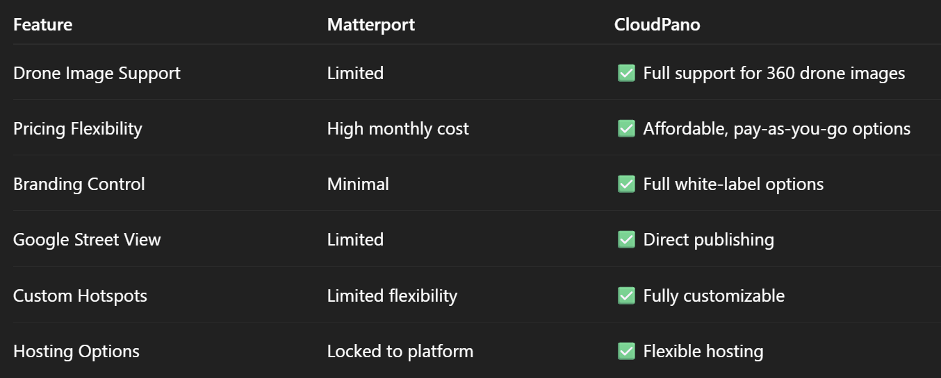
Drone pilots invest in premium gear for crisp imagery. CloudPano preserves your 4K and above uploads without heavy compression.

2️⃣ Immersive Hotspot Navigation

Create clickable points that guide viewers through the tour, from an aerial overview into interior spaces.

3️⃣ Seamless Google Street View Upload

With one click, publish your aerial 360° captures to Google Street View, boosting SEO and visibility.

4️⃣ White-Label Branding for Agencies

Want to keep your name in front of clients? CloudPano lets you remove all third-party branding and use your own logo, colors, and domain.

5️⃣ Flexible Pricing

Whether you create one drone tour a month or hundreds, CloudPano offers scalable plans without forcing you into an expensive monthly lock-in.

🏗 Real-World Applications for Drone Virtual Tours

  • Real Estate Marketing 🏡 – Show buyers a unique perspective of large properties or luxury estates.
  • Resort & Hospitality 🏖 – Highlight beaches, pools, golf courses, and amenities.
  • Construction Progress Tracking 🏗 – Document builds from foundation to final touches.
  • Agriculture & Land Sales 🌾 – Showcase vast farmlands, ranches, or undeveloped plots.
  • Insurance & Inspection 🔍 – Provide clear aerial evidence for claims and assessments.

📸 Case Study: From Aerial Capture to Closing the Deal

A Florida real estate photographer recently switched from Matterport to CloudPano for drone-based beachfront property tours. The result?

  • 50% faster upload times
  • Higher resolution playback
  • Immediate Google Street View visibility
  • A sale in under 30 days thanks to increased online engagement

🥇 Why CloudPano Is the Best Choice Over Matterport

  1. Better for Drones – Optimized for high-res panoramic images from aerial cameras.
  2. More Affordable – Flexible pricing with no forced annual contracts.
  3. Brand Control – White-label features for agencies and independent photographers.
  4. Faster Delivery – Easy upload, edit, and publish workflow.
  5. Broader Integration – Google Street View, MLS, and more.

🎯 Final Takeaway

If you’re a drone pilot, photographer, or agency looking for the top Matterport alternative for aerial virtual tours, CloudPano offers more control, better pricing, and superior image handling than its competitors.

📢 Call-to-Action Block

🔥 Ready to launch your first aerial drone virtual tour?

Share this post
Cloudpano

Choose The Right 360° Camera

Insta360 ONE RS 1-Inch 360 Edition

  • Compact, ready to go anywhere

  • Interchangeable lens that’s upgradeable

  • Dual 1-inch sensors for improved clarity and low light performance

  • Dynamic range and 6K 360° capture

  • 360° photo resolution at 21MP

Learn More

Insta360 X4

  • 8K 360° video recording for ultra-detailed visuals.

  • 4K single-lens mode for traditional wide-angle shots.

  • Invisible selfie stick effect for drone-like perspectives.

  • 2.5-inch touchscreen with Gorilla Glass protection.

  • Waterproof up to 33ft for underwater shooting.

Learn More

Ricoh Theta Z1

  • 360° photo resolution in 23MP

  • Slim design at 24 mm thick

  • Built-in image stabilization for smooth video capture.

  • Internal 19GB storage for photo and video storage.

  • Wireless connectivity for remote control and sharing.

Learn More

Ricoh Theta X

  • 60MP 360° still images for high-resolution photography.

  • 5.7K 360° video recording at 30fps.

  • 2.25-inch touchscreen for intuitive control.

  • USB Type-C port for fast charging and data transfer.

  • MicroSD card slot for expandable storage.

Learn More
Property Marketing
Allows potential buyers to explore properties in detail from anywhere, enhancing the real estate marketing process.
Automotive Spins
Create an interactive virtual showroom and engage affluent digital buyers with live 360º video calls, all through the CloudPano mobile app for a complete automotive sales solution.
Interactive Floor Plans
Create 2D and 3D floor plans with measurements in 4 minutes or less, all from your phone. Download the Floor Plan Scanner app and get your first scan free.

360 Virtual Tours With CloudPano.com. Get Started Today.

Try it free. No credit card required. Instant set-up.

Try it free
Latest posts

See our other posts

Interviews, tips, guides, industry best practices, and news.

Mastering Compliance: The Future of Automated Property Video

This article provides a definitive guide for real estate professionals on navigating strict MLS branding regulations through AI-driven automation. It addresses the risks of compliance violations, details the limitations of manual editing workflows, and introduces a scalable, "compliance-first" system for generating high-quality, MLS-approved property videos. The post serves as a strategic blueprint for agents aiming to maintain listing visibility, avoid regulatory penalties, and streamline their marketing operations.
Read post

Future-Proofing Your Business with MLS Safe AI Video for Listings

This high-authority guide focuses on long-term operational stability and the strategic advantages of leveraging artificial intelligence to bypass the industry-wide friction between high-impact marketing and regulatory compliance. Key Takeaways & Content Structure: The Reputation-Risk Factor: Explains the high cost of compliance errors, focusing on how a single technical oversight—such as a misplaced logo or branded watermark—can trigger a systemic board audit, leading to immediate listing suspension and lasting reputational damage with sellers. The Production Disconnect: Breaks down the "two-version" operational tax, where marketing teams suffer from repetitive rendering, file-management bloat, and the persistent danger of human error when manually managing branded vs. unbranded media assets. AI as a Compliance Engine: Defines how advanced AI media platforms move beyond mere aesthetics to function as regulatory safeguards. It illustrates the technical architecture where the AI engine isolates branding data from structural property data at the rendering level, effectively "forking" the output into two distinct, safe-to-use tracks. Operational Blueprint: Maps out a transparent, 6-step automation funnel that takes a listing from flat photograph ingestion to syndicate-ready, neutral-hosted media in minutes. Strategic Scalability: Demonstrates why centralizing production into a single SaaS platform is the only way for growing brokerages to maintain consistency, remove contractor-level liability, and recover significant administrative time. The PhotoAIVideo.com Edge: Concludes by positioning the platform as a purpose-built solution that combines high-definition parallax AI motion with an automated "compliance-first" export workflow, ensuring Realtors can generate professional, engaging video content that passes even the most stringent board audits on the first attempt.
Read post

Streamlining Your Workflow with a Specialized MLS Compliant Real Estate Media App

This article functions as a tactical operations guide for real estate marketers and brokerage leaders focused on reducing technical friction and human error in their media publishing pipeline. Key Takeaways & Content Structure: The "Stop-Work" Order: Addresses the high-stakes reality of MLS compliance flags, where automated rules block properties from IDX feeds due to accidental branding, causing immediate listing velocity loss. The Fragmented Workflow Problem: Identifies the "manual bottleneck"—the inefficiency of having field photographers deliver single assets that then require internal staff to manually strip, re-render, and verify separate branded and unbranded versions. Architecture of Dual-Path Rendering: Illustrates the technological shift toward programmatic asset management. It explains how a modern app processes a single source file into two isolated rendering tracks: a lead-gen-heavy marketing track and a strictly compliant, unbranded track for MLS syndication. Operational Workflow Mapping: Provides a clear, 6-step blueprint for moving from raw photography ingestion to compliant deployment, including automated motion application, metadata scrubbing, and neutral link hosting. Risk Mitigation for Brokerages: Highlights how centralized management dashboards eliminate the "wild west" of agent-led media creation, providing brokers with a single-pane-of-glass view to ensure compliance across all active listings. The PhotoAIVideo.com Advantage: Positions the platform as the ideal MLS compliant real estate media app that leverages AI to inject cinematic motion into flat listing photos, effectively automating the entire compliance-forking process and increasing overall production capacity by up to 94%.
Read post