Annotating Data for Spatial AI and 3D Scene Understanding

Cloudpano
July 31, 2026
5 min read
Share this post

Annotating Data for Spatial AI and 3D Scene Understanding

Teams moving from standard image labeling into spatial AI data annotation often assume the transition is mostly a tooling upgrade. It isn't. Annotating three-dimensional space — where an object has depth, orientation, and a real position relative to a sensor — requires a genuinely different set of skills and quality checks than marking objects in a flat image.

3D Data Annotation deals with information a 2D bounding box simply doesn't capture: how far away an object actually is, which direction it's facing, and how its position changes across a sequence of frames. That added dimensionality is exactly what makes spatial annotation both more valuable for certain tasks and considerably harder to do well.

Why It Matters

A model trained on spatial data needs annotations that accurately represent real-world geometry, and errors here don't just misplace a label — they misrepresent an object's actual distance, size, or trajectory in ways that directly affect a downstream system's real-world decisions. Google Research's "Data Cascades" study documented how data quality issues that seem minor early on compound into larger problems as they propagate through a pipeline, a pattern with particularly serious consequences when the data in question represents physical space a system will act within (Sambasivan et al., Google Research).
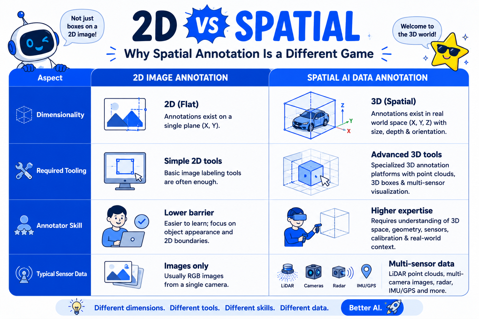
Comparison table of 2D image annotation vs spatial AI data annotation

NIST's AI Risk Management Framework treats data quality and fitness for the intended task as foundational to trustworthy AI, a standard that carries extra weight for Spatial AI Training Data used in physically-acting systems like robotics or autonomous vehicles, where an annotation error translates more directly into a real-world safety concern than it might for a purely digital application (NIST AI RMF).

The stakes rise as spatial AI applications expand. Stanford HAI's AI Index has tracked growing deployment of AI systems that interact with physical environments, including robotics and autonomous systems (Stanford HAI, AI Index Report), and the annotation quality behind these systems carries consequences that are harder to reverse than a mislabeled photo.

How It Works

LiDAR Annotation Services and broader spatial annotation work generally involve a few distinct components.
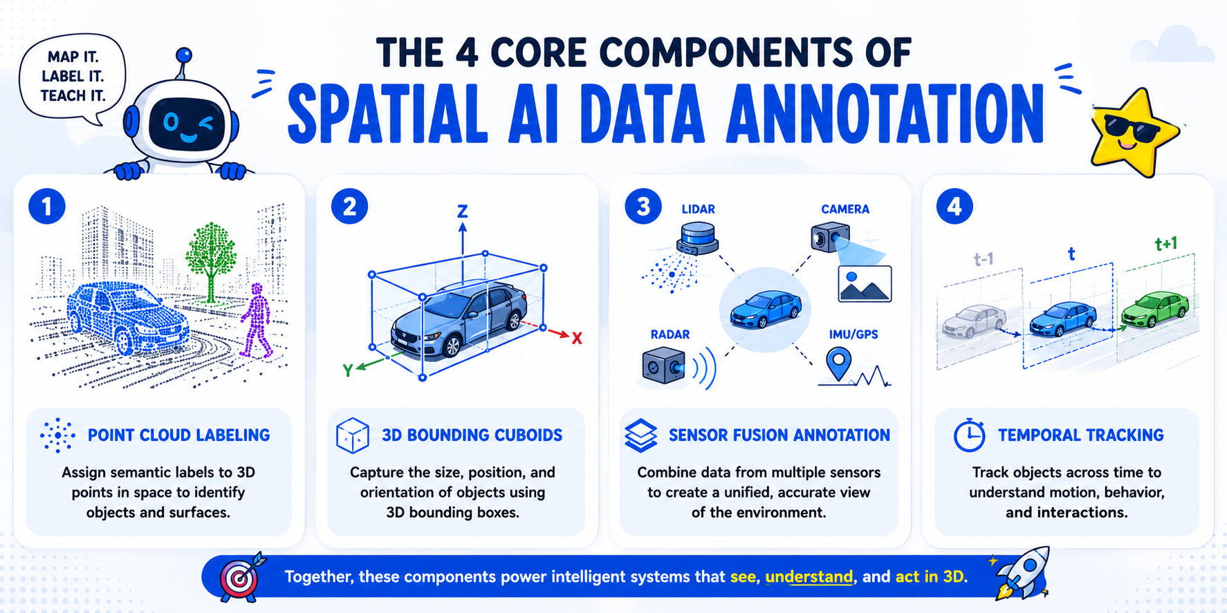
Point cloud labeling. LiDAR sensors produce a cloud of individual 3D points representing detected surfaces; annotators classify or group these points by object category, working in three-dimensional space rather than a flat image plane.

3D bounding cuboids. Similar in concept to a 2D bounding box, but defined by additional dimensions — length, width, height, and orientation — to represent an object's actual position and rotation in 3D space.
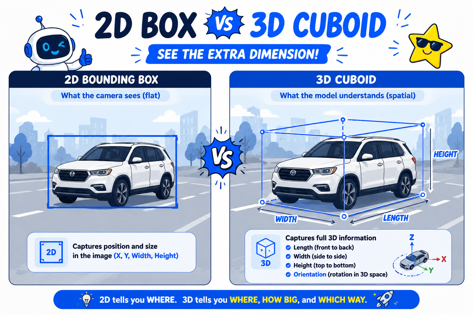
Illustration comparing a 2D bounding box to a 3D cuboid in spatial AI data annotation

Sensor fusion annotation. Many spatial AI systems combine LiDAR, camera, and radar data, requiring annotation that stays consistent across multiple sensor modalities describing the same physical scene.

Temporal tracking across frames. For moving objects, annotation needs to track a consistent identity across a sequence of frames, not just label each frame independently.

Understanding how these workflows operate as genuinely spatial work — annotators reasoning in three dimensions, not clicking through flat images — is what separates a properly scoped spatial AI project from one that underestimates the skill and tooling this work actually requires.

Step-by-Step Workflow

  • Determine which sensor modalities your project actually uses. LiDAR-only, camera-only, or a fused multi-sensor approach each require different annotation tooling and skill.
  • Select tooling built specifically for 3D annotation. Point cloud visualization and cuboid placement require software genuinely different from standard 2D bounding box tools.
  • Write annotation guidelines addressing 3D-specific ambiguity. Occlusion, sensor noise, and object orientation ambiguity all need explicit guidance that 2D annotation guidelines don't typically cover.
  • Recruit or train annotators with spatial reasoning skill. Working accurately in 3D space is a distinct competency from 2D image annotation and generally requires dedicated training.
  • Pilot the annotation process on representative sensor data. Confirm tooling, guidelines, and annotator skill actually produce usable spatial training data before scaling volume.
  • Apply quality assurance specific to spatial accuracy. Check cuboid dimension and orientation accuracy, point cloud classification consistency, and cross-frame tracking continuity.
  • Validate annotated data against the model's actual spatial requirements. Confirm the annotation format and precision genuinely support the specific spatial AI architecture being trained.

Industry Use Cases

  • Autonomous vehicles: This is the primary use case for spatial annotation, combining LiDAR point cloud labeling, 3D cuboids, and multi-sensor fusion for real-time scene understanding.
  • Robotics: Spatial annotation supports manipulation and navigation tasks, where a robot needs an accurate understanding of object position and orientation in its physical workspace.
  • Manufacturing AI: 3D annotation supports quality inspection systems using depth sensors to detect precise physical defects that 2D imaging alone might miss.
  • Government & defense: Spatial annotation applies to geospatial and 3D terrain analysis, often layered with strict security requirements given the sensitivity of the underlying sensor data.
  • Healthcare AI: 3D annotation is used for volumetric medical imaging, where understanding structures across depth, not just a flat slice, matters for diagnostic accuracy.
  • Retail AI: Spatial annotation has more limited application here, generally confined to specific use cases like in-store 3D mapping rather than standard product detection tasks.

Benefits

  • Training data that reflects real physical geometry. Accurate 3D annotation gives a model genuine spatial understanding rather than an approximation based on 2D projections alone.
  • Better support for physically-acting systems. Robotics and autonomous vehicle applications depend on spatial accuracy that 2D-only annotation simply can't provide.
  • More reliable object tracking across time. Temporal annotation supports models that need to understand not just where an object is, but how it's moving.
  • Improved sensor fusion model performance. Consistent annotation across LiDAR, camera, and radar data helps a model learn to combine these inputs coherently.
  • Reduced downstream safety risk. More accurate spatial training data reduces the chance of a physically-acting system misjudging distance, size, or trajectory in deployment.

Common Mistakes

  • Treating 3D annotation as an extension of 2D image labeling. Assuming annotators skilled in bounding boxes can transition to spatial work without dedicated training.
  • Using tooling not built for point cloud or cuboid work. Attempting to adapt standard 2D annotation software rather than investing in purpose-built spatial annotation tools.
  • Writing guidelines that don't address 3D-specific ambiguity. Missing explicit guidance for occlusion, sensor noise, and orientation judgment calls unique to spatial data.
  • Skipping cross-sensor consistency checks in fusion projects. Annotating each sensor modality independently without verifying the labels agree on the same physical scene.
  • Underestimating the time and cost of spatial annotation. Scoping 3D annotation projects with 2D-equivalent budget and timeline assumptions.
  • Not validating temporal tracking continuity. Missing broken object identity across frames, which undermines a model's ability to learn consistent motion patterns.

Best Practices

  • Select annotation tooling built specifically for point cloud and 3D cuboid work rather than adapting 2D-focused software.
  • Train annotators specifically in spatial reasoning, treating it as a distinct skill from standard image annotation.
  • Write guidelines that explicitly address 3D-specific ambiguity, including occlusion and sensor noise handling.
  • Apply quality assurance checks specific to spatial accuracy — cuboid dimensions, orientation, and cross-frame tracking continuity.
  • Verify consistency across sensor modalities in any project combining LiDAR, camera, and radar annotation.
  • Budget realistically for the added time and specialized skill spatial annotation genuinely requires compared to 2D work.

FAQ

What is spatial AI data annotation?

The process of labeling three-dimensional sensor data — typically LiDAR point clouds or depth-camera output — with 3D bounding cuboids, point classifications, or object trajectories to train models that understand real-world space.

How is 3D data annotation different from standard 2D image annotation?

3D annotation requires reasoning about depth, orientation, and physical position in three-dimensional space, using different tooling and annotator skills than marking objects in a flat, two-dimensional image.

What do LiDAR annotation services typically involve?

Point cloud classification, where individual 3D points detected by a LiDAR sensor are labeled by object category, along with 3D bounding cuboid placement to represent an object's position and rotation in space.

Why does spatial AI training data need cross-sensor consistency checks?

Because many spatial AI systems fuse data from LiDAR, camera, and radar sensors, and annotations describing the same physical scene need to agree across modalities for the model to learn to combine them coherently.

Can 2D annotation experience transfer directly to spatial AI annotation work?

Not fully. Spatial reasoning in three dimensions is a distinct skill, and annotators typically need dedicated training even if they have strong 2D image annotation experience.

Why is temporal tracking important in spatial annotation?

Because many spatial AI applications need to understand how an object moves over time, not just where it is in a single frame, which requires maintaining consistent object identity across a sequence of frames.

What industries rely most heavily on spatial AI data annotation?

Autonomous vehicles and robotics rely on it most directly, with meaningful use in manufacturing quality inspection, government geospatial analysis, and volumetric medical imaging as well.

Conclusion

Spatial AI data annotation is a genuinely distinct discipline from standard image labeling, not a simple extension of it. Point cloud classification, 3D cuboid placement, sensor fusion consistency, and temporal tracking each require specific tooling, annotator skill, and quality assurance that 2D-focused annotation practices don't address. Scoping a spatial AI project with that distinction in mind, rather than assuming it's just image annotation with an extra dimension, is what actually produces training data a physically-acting system can rely on.

🚀 Your All‑In‑One Virtual Experience Stack
🎬
PhotoAIVideo
Turn photos into scroll‑stopping AI videos.
Get Started →
🏡
Pictastic
Instantly stage listings with AI.
Try Staging →
🌀
CloudPano
Create stunning 360° tours in minutes.
Launch Tour →
💰
VirtualTourProfit
Build a profitable virtual tour business.
Learn More →
🤝
CloudPano Reseller
Resell AI visual software without building it.
Become a Reseller →
🚗
Auto CloudPano
Sell more vehicles with 360° experiences.
Explore Auto →
🏗️
AI Floor Plan Builder
Generate detailed floor plans with AI.
Build Now →
📐
3D Measure
Capture accurate floor plans & 3D measurements.
Measure Now →
🧠
AI Training Data
Custom AI training data services.
Learn More →
Share this post
Cloudpano

Choose The Right 360° Camera

Insta360 ONE RS 1-Inch 360 Edition

  • Compact, ready to go anywhere

  • Interchangeable lens that’s upgradeable

  • Dual 1-inch sensors for improved clarity and low light performance

  • Dynamic range and 6K 360° capture

  • 360° photo resolution at 21MP

Learn More

Insta360 X4

  • 8K 360° video recording for ultra-detailed visuals.

  • 4K single-lens mode for traditional wide-angle shots.

  • Invisible selfie stick effect for drone-like perspectives.

  • 2.5-inch touchscreen with Gorilla Glass protection.

  • Waterproof up to 33ft for underwater shooting.

Learn More

Ricoh Theta Z1

  • 360° photo resolution in 23MP

  • Slim design at 24 mm thick

  • Built-in image stabilization for smooth video capture.

  • Internal 19GB storage for photo and video storage.

  • Wireless connectivity for remote control and sharing.

Learn More

Ricoh Theta X

  • 60MP 360° still images for high-resolution photography.

  • 5.7K 360° video recording at 30fps.

  • 2.25-inch touchscreen for intuitive control.

  • USB Type-C port for fast charging and data transfer.

  • MicroSD card slot for expandable storage.

Learn More
Property Marketing
Allows potential buyers to explore properties in detail from anywhere, enhancing the real estate marketing process.
Automotive Spins
Create an interactive virtual showroom and engage affluent digital buyers with live 360º video calls, all through the CloudPano mobile app for a complete automotive sales solution.
Interactive Floor Plans
Create 2D and 3D floor plans with measurements in 4 minutes or less, all from your phone. Download the Floor Plan Scanner app and get your first scan free.

360 Virtual Tours With CloudPano.com. Get Started Today.

Try it free. No credit card required. Instant set-up.

Try it free
Latest posts

See our other posts

Interviews, tips, guides, industry best practices, and news.

Computer Vision Annotation for Robotics and Autonomous Systems

Computer vision annotation robotics teams need goes beyond standard object detection — it includes grasp point and manipulation annotation, human-robot interaction safety zone labeling, and simulation-to-real data alignment. These robotics-specific requirements differ from general object detection or vehicle-focused spatial annotation, since robots must physically act on what they perceive.
Read post

Annotating Data for Spatial AI and 3D Scene Understanding

Spatial AI data annotation labels three-dimensional sensor data — typically LiDAR point clouds or depth-camera output — with 3D bounding cuboids, per-point classifications, or tracked object trajectories across frames. It requires different tooling, annotator skill, and quality checks than standard 2D image annotation, since objects exist in real three-dimensional space, not a flat plane.
Read post

Computer Vision Annotation Types Explained: Bounding Boxes, Polygons, and Segmentation

Computer vision annotation types differ mainly in how precisely they capture an object's shape. Bounding boxes draw a rectangle around an object, polygon annotation traces its actual outline with straight-line vertices, and semantic segmentation labels every pixel by category. Each format trades precision against annotation speed and cost differently.
Read post