


.png)

In today’s competitive real estate and commercial marketing space, drone 360° tours have gone from “nice-to-have” to absolutely essential. These tours create jaw-dropping, fully immersive experiences that let buyers, investors, and tenants explore a property from every angle — even from the sky. 🌎✨
But here’s the big question: Which platform should you use to host and showcase your high-impact drone 360° tours?
If you’ve been considering Matterport, you might want to take a closer look at CloudPano — the platform that’s rapidly becoming the go-to Matterport alternative for creators, marketers, and real estate pros who want more flexibility, affordability, and creative freedom.
In this guide, we’ll break down why CloudPano is the top choice for drone-based 360° tours — and we’ll link you to other must-read comparisons like Best Matterport Alternatives for Real Estate Agents and CloudPano vs Matterport: Which Virtual Tour Platform Is Right for You?.
Drone 360° tours let you:
With the right platform, you can combine aerial shots with ground-level 360° views, creating a seamless virtual walk-through experience. And that’s where CloudPano excels.
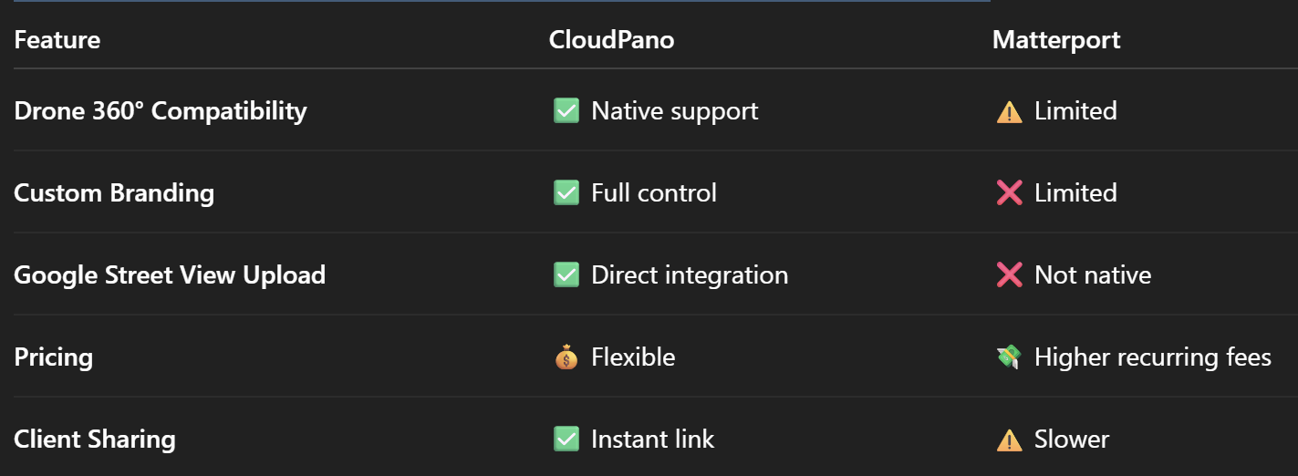
While Matterport is known for its interior scanning capabilities, it’s not optimized for aerial 360° drone content. The drawbacks include:
If you’ve ever tried uploading a drone 360° to Matterport, you know the process can be clunky and restrictive.
That’s why many pros are switching to CloudPano after reading guides like Looking for a Matterport Alternative? Here’s Why Real Estate Pros Choose CloudPano and Best Matterport Alternatives for Realtors: How CloudPano Delivers More Value.
Here’s why CloudPano wins for drone-based 360° tours:
Upload and publish your drone panoramas in minutes, with full compatibility for aerial and ground shots in the same tour.
Add custom logos, colors, and domain names so your tours match your brand — a must for professionals and agencies.
Unlike Matterport’s subscription-heavy pricing, CloudPano offers pay-once lifetime access and low-cost hosting.
Publish drone 360° views directly to Google Street View — boosting local SEO and visibility.
(Related reading: CloudPano: The Leading Matterport Alternative with Google Street View Uploads)
Share a single link that works perfectly on desktop, mobile, and VR headsets. No special software required.
A commercial real estate agent in Florida recently used CloudPano for a mixed aerial + interior virtual tour.
Results:
For more comparisons, check out Matterport vs CloudPano: Which Virtual Tour Software Offers More Flexibility? and CloudPano vs Matterport for Real Estate Agents: A Detailed Comparison Guide.
The demand for immersive drone tours is exploding in real estate, hospitality, and commercial marketing. By switching to CloudPano now, you’ll:
With CloudPano, you can upload, customize, and publish stunning drone tours in minutes. Whether you’re a real estate photographer, drone pilot, or commercial marketing pro — this is your chance to elevate your offerings and wow your clients.
📌 Start your first tour now with CloudPano and see the difference for yourself.

Compact, ready to go anywhere
Interchangeable lens that’s upgradeable
Dual 1-inch sensors for improved clarity and low light performance
Dynamic range and 6K 360° capture
360° photo resolution at 21MP

8K 360° video recording for ultra-detailed visuals.
4K single-lens mode for traditional wide-angle shots.
Invisible selfie stick effect for drone-like perspectives.
2.5-inch touchscreen with Gorilla Glass protection.
Waterproof up to 33ft for underwater shooting.

360° photo resolution in 23MP
Slim design at 24 mm thick
Built-in image stabilization for smooth video capture.
Internal 19GB storage for photo and video storage.
Wireless connectivity for remote control and sharing.

60MP 360° still images for high-resolution photography.
5.7K 360° video recording at 30fps.
2.25-inch touchscreen for intuitive control.
USB Type-C port for fast charging and data transfer.
MicroSD card slot for expandable storage.
.png)
.png)

Try it free. No credit card required. Instant set-up.


