Matterport Alternative for Construction Progress Tracking

Cloudpano
August 7, 2025
5 min read
Share this post

Matterport Alternative for Construction Progress Tracking 🚧📸

Why CloudPano Is the Smarter, Faster, and More Affordable Choice in 2025

In the fast-paced world of construction, progress visibility is everything. Whether you're managing a new development, commercial renovation, or custom build, being able to document, verify, and share progress across teams and clients is critical.

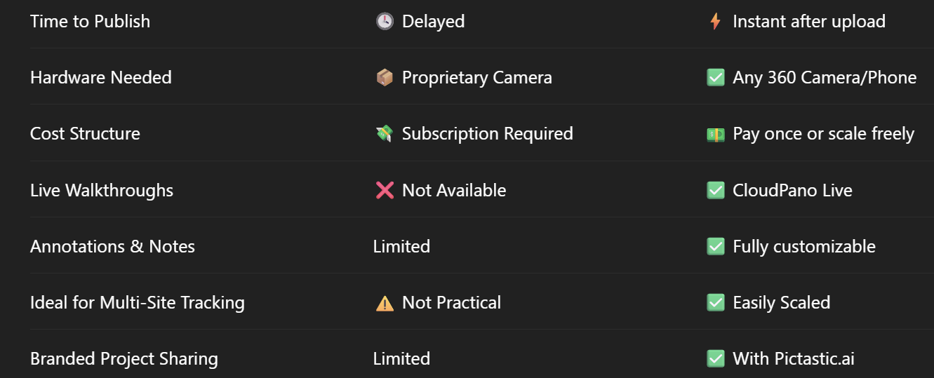
While Matterport has gained popularity for its immersive scans, its pricing, hardware limitations, and complex workflow have opened the door for more agile alternatives.

Meet CloudPano — the best Matterport alternative for construction progress tracking in 2025. It’s affordable, lightning-fast, easy to use, and designed for teams who need results now — not after days of processing or subscriptions.

🏗️ Why 360° Tours Matter in Construction Progress 📅

Construction documentation isn't just about capturing pretty pictures — it's about:

  • 🔍 Tracking and verifying contractor milestones
  • 📤 Sharing real-time updates with stakeholders
  • 📋 Meeting compliance and inspection requirements
  • 📊 Reducing disputes, change orders, and delays
  • 📁 Creating a visual audit trail of the build process

360° tours make it possible to walk through a site remotely and compare current conditions to architectural plans, timelines, and expectations.

🚫 Why Matterport Falls Short on the Job Site

Matterport delivers beautiful visuals — but in construction workflows, it shows its cracks:

  • 💸 High upfront hardware costs (Pro cameras required)
  • 🔐 Monthly subscription and hosting fees
  • ⏱️ Slower turnaround due to processing times
  • No built-in live walkthroughs
  • 🧱 Limited flexibility with annotations or branding

For construction managers, architects, and owners juggling tight schedules and multiple projects, these limitations can be deal-breakers.

✅ Why CloudPano is the Best Matterport Alternative for Construction

CloudPano is a browser-based 360° virtual tour software that empowers construction teams to:

  • 🛠️ Capture, organize, and share progress fast
  • 📸 Use any 360° camera or even mobile panoramas
  • 🔗 Create hotspot-based navigation across rooms or floors
  • 🖼️ Add labels, annotations, and visual notes
  • 🔴 Host live video walkthroughs with clients
  • 📤 Publish and share instantly (no processing delay)
  • 💰 Avoid monthly fees with lifetime or per-tour plans

👉 Try CloudPano now → https://www.cloudpano.com

🧱 CloudPano in Action: Construction Use Cases

🔄 Time-Lapse Documentation

Capture weekly or bi-weekly 360° walkthroughs to compare progress visually — essential for investors, lenders, or compliance auditors.

📅 Subcontractor Coordination

Link tours to project management tools and reduce on-site visits by enabling remote access to site visuals.

👉 Related: From Damage to Documentation: Using 360 Virtual Tours for Claims Processing

🧾 Compliance & Inspection

Ensure milestones are visually documented for:

  • Structural inspections
  • Code enforcement
  • Warranty tracking
  • Insurance documentation

📈 Stakeholder Updates

Use CloudPano Live to walk stakeholders through progress in real time, answering questions and avoiding surprises.

👉 Related: Insurance Claims and the Rise of 360° Property Documentation

🧰 Pair With AI Video & Client Delivery Tools

Need to share project progress in more formats?

Use these companion tools built for construction and architecture workflows:

🎞️ PhotoAIVideo.com

Convert site images into automated walkthrough videos with:

  • Motion pans
  • Captions and narration
  • Music and branding
  • Progress highlights

Great for internal updates, investor reports, or proposal recaps.

👉 Related: How to Generate Real Estate Videos From Just Photos in Under 5 Minutes

🗂️ Pictastic.ai

Deliver your CloudPano tours, AI videos, and images in one professional, client-ready portal.

You can:

  • 🖼️ Add company branding
  • 🧾 Track project files, notes, and progress
  • 📤 Share with stakeholders, cities, or consultants

👉 Related: Pictastic Virtual Staging

🔍 CloudPano vs. Matterport: Construction Comparison Table

💬 What Contractors & Managers Say

“We dropped Matterport when CloudPano let us publish 360° walkthroughs in 10 minutes. Clients love it, and our margins are better.”
— Terry R., GC in Austin, TX

“I can walk owners through every floor, every week — even if they’re out of state. CloudPano Live saves me hours.”
— Jasmine K., PM for multifamily builds

🔧 Your Next Steps:

Share this post
Cloudpano

Choose The Right 360° Camera

Insta360 ONE RS 1-Inch 360 Edition

  • Compact, ready to go anywhere

  • Interchangeable lens that’s upgradeable

  • Dual 1-inch sensors for improved clarity and low light performance

  • Dynamic range and 6K 360° capture

  • 360° photo resolution at 21MP

Learn More

Insta360 X4

  • 8K 360° video recording for ultra-detailed visuals.

  • 4K single-lens mode for traditional wide-angle shots.

  • Invisible selfie stick effect for drone-like perspectives.

  • 2.5-inch touchscreen with Gorilla Glass protection.

  • Waterproof up to 33ft for underwater shooting.

Learn More

Ricoh Theta Z1

  • 360° photo resolution in 23MP

  • Slim design at 24 mm thick

  • Built-in image stabilization for smooth video capture.

  • Internal 19GB storage for photo and video storage.

  • Wireless connectivity for remote control and sharing.

Learn More

Ricoh Theta X

  • 60MP 360° still images for high-resolution photography.

  • 5.7K 360° video recording at 30fps.

  • 2.25-inch touchscreen for intuitive control.

  • USB Type-C port for fast charging and data transfer.

  • MicroSD card slot for expandable storage.

Learn More
Property Marketing
Allows potential buyers to explore properties in detail from anywhere, enhancing the real estate marketing process.
Automotive Spins
Create an interactive virtual showroom and engage affluent digital buyers with live 360º video calls, all through the CloudPano mobile app for a complete automotive sales solution.
Interactive Floor Plans
Create 2D and 3D floor plans with measurements in 4 minutes or less, all from your phone. Download the Floor Plan Scanner app and get your first scan free.

360 Virtual Tours With CloudPano.com. Get Started Today.

Try it free. No credit card required. Instant set-up.

Try it free
Latest posts

See our other posts

Interviews, tips, guides, industry best practices, and news.

CloudPano: The Leading Matterport Alternative with Google Street View Uploads

This in-depth blog post explores why CloudPano is the top Matterport alternative in 2025, especially for professionals who want direct Google Street View publishing. We break down CloudPano’s flexibility, camera compatibility, white-label features, and integrations with tools like PhotoAIVideo and Pictastic. If you're a real estate agent, 360 photographer, or virtual tour creator looking to upgrade your workflow and boost visibility, this guide explains why CloudPano is the clear winner.
Read post

Best Virtual Tour Platforms Like Matterport That Support Google Street View

Explores the best Matterport-style virtual tour platforms that support Google Street View in 2025. It breaks down why CloudPano is the superior choice for real estate agents, agencies, and 360° creators — offering direct GSV publishing, full camera flexibility, white-labeled delivery, and integration with tools like PhotoAIVideo and Pictastic. Learn how CloudPano helps you showcase properties, rank higher in Google Maps, and deliver client-ready virtual tours with ease.
Read post

Top Matterport Alternatives with Google Street View Integration in 2025

Explores the top Matterport alternatives that support Google Street View integration in 2025. It highlights why CloudPano is the most flexible, scalable, and cost-effective platform for real estate professionals, 360° photographers, and agencies. From direct Street View publishing and full branding control to compatibility with any 360 camera, CloudPano stands out as the best option for professionals who want to own their virtual tour workflow and maximize Google Maps visibility.
Read post