Improve Incident Response in Oil and Gas with 360° Safety Documentation

Cloudpano
July 21, 2025
5 min read
Share this post

🚨 Improve Incident Response in Oil and Gas with 360° Safety Documentation 🛢️📷

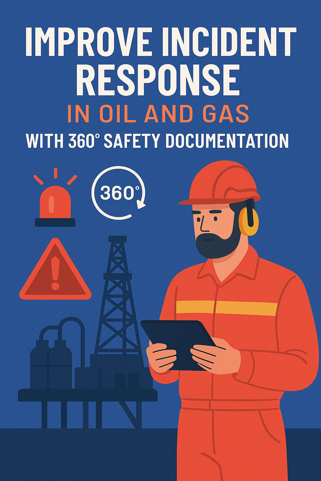
When an incident strikes in the oil and gas industry, every second counts. Whether it’s a gas leak, equipment failure, or fire hazard, response time and accurate situational awareness can mean the difference between a close call and a catastrophe. 🕒🔥

That’s where 360° safety documentation is changing the game. By capturing every detail of a site virtually, teams can train more effectively, audit more efficiently, and respond to emergencies with greater confidence and speed. 🧠🦺

Let’s break down how 360° documentation tools are helping oil and gas teams boost response preparedness, reduce downtime, and enhance safety compliance.

🧭 What is 360° Safety Documentation?

360° safety documentation involves capturing immersive visual data of an oilfield, refinery, or pipeline site using panoramic cameras or drones. The data is then turned into an interactive virtual environment that replicates real-world conditions.

This digital replica allows:

  • 🚶 Teams to explore the environment virtually
  • ⚠️ Hazards to be pre-tagged and explained
  • 🧯 Response protocols to be embedded into specific locations
  • 📋 Site knowledge to be preserved for future training and audits

👉 Related: Why 360° Documentation Software Is Essential for Oil and Gas Safety Training

🚒 Why Incident Response Needs a Digital Upgrade

The traditional approach to incident response — paper manuals, static maps, and classroom briefings — simply can’t keep up with the scale and complexity of modern oil operations. 📉

Some challenges include:

  • Delays due to unfamiliar terrain or outdated schematics
  • Miscommunication between remote and on-site teams
  • Slow contractor onboarding and site-specific safety orientation
  • Inability to simulate real hazard scenarios

With 360° documentation, you bring the site to the team — before the incident even happens. 👨‍🏫💻

🔄 5 Ways 360° Documentation Enhances Incident Response

1. ✅ Pre-Incident Familiarization

Emergency response teams can virtually walk through the facility beforehand. They’ll know:

  • Evacuation routes 🏃
  • Valve shut-off locations 🛠️
  • High-risk zones ☢️
  • Emergency equipment placements 🧯

👉 Dive deeper: Step Into Safety: Virtual Tours for Oil and Gas Industry Training

2. 🧰 Real-Time Coordination

During an incident, remote support teams can view the same 360° scene as on-site personnel — making coordination smoother and more accurate. 📡

You can:

  • Highlight exact locations
  • Simulate containment routes
  • Provide on-the-spot guidance

👉 Related read: Using VR and 360 Tours for Safer Oil and Gas Work Environments

3. 🕵️ Faster Investigations

After an incident, 360° records can help safety officers and auditors review the exact pre-incident environment — no guesswork, no miscommunication.

This streamlines:

  • Root cause analysis 🔍
  • Regulatory documentation 📑
  • Insurance claims 📈

👉 Explore: Streamlining Compliance: 360° Safety Documentation in the Oil and Gas Sector

4. 👷 Improved Contractor Readiness

New contractors or emergency crews unfamiliar with the site can take a virtual safety orientation tour before stepping foot on location.

This reduces:

  • Training delays
  • Risk of non-compliance
  • Onboarding costs

👉 Resource: Preparing New Hires with Oil and Gas Virtual Safety Orientation Tours

5. 🧠 Smarter Safety Drills

360° safety documentation enables interactive emergency simulations. Instead of boring briefings, crews can practice with:

  • Immersive hazard scenarios
  • Click-to-respond training modules
  • Digital badges for drill completions

👉 Read next: Oilfield Training Reimagined: Safety Simulations Through Virtual Tours

🔗 Internal Links for Advanced Learning

For a complete digital safety ecosystem, explore these additional resources:

  1. 📸 Using 360° Site Capture for Real-Time Oil and Gas Safety Training
  2. 🧪 Visualize Safety Hazards: The Power of Virtual Training Tours in Oil and Gas
  3. 🧬 Digital Twins and Safety: Virtual Tour Integration in Oil and Gas Training

📊 Case Study Snapshot

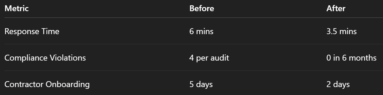
Company: GulfCo Drilling
Problem: Delayed response time to refinery fire drills
Solution: Implemented 360° documentation and VR-based training

Results:

🛠️ Getting Started with 360° Safety Documentation

Step 1: Choose a 360° Camera or Drone

Recommended: Ricoh Theta Z1, Insta360, or DJI drones for aerial mapping.

Step 2: Capture the Environment

Cover:

  • Control panels
  • Emergency exits
  • Hazardous materials
  • Evacuation zones

Step 3: Build the Interactive Tour

Use platforms like:

  • CloudPano
  • Matterport
  • Kuula
  • 3DVista

👉 Guide: How to Create an Oil and Gas Safety Training Virtual Tour That Saves Lives

🏁 Final Thoughts

In a field where lives are on the line, investing in 360° safety documentation is a no-brainer. It empowers faster, smarter, and safer incident response — and it pays dividends in audit performance, crew safety, and operational readiness. 💡

👉 Ready to upgrade your incident response strategy?

Start here: Boost Oil and Gas Safety with 360° Documentation and Virtual Tours

And check out: Transform Your Oilfield Safety Training with 360° Tour Documentation Tools

Share this post
Cloudpano

Choose The Right 360° Camera

Insta360 ONE RS 1-Inch 360 Edition

  • Compact, ready to go anywhere

  • Interchangeable lens that’s upgradeable

  • Dual 1-inch sensors for improved clarity and low light performance

  • Dynamic range and 6K 360° capture

  • 360° photo resolution at 21MP

Learn More

Insta360 X4

  • 8K 360° video recording for ultra-detailed visuals.

  • 4K single-lens mode for traditional wide-angle shots.

  • Invisible selfie stick effect for drone-like perspectives.

  • 2.5-inch touchscreen with Gorilla Glass protection.

  • Waterproof up to 33ft for underwater shooting.

Learn More

Ricoh Theta Z1

  • 360° photo resolution in 23MP

  • Slim design at 24 mm thick

  • Built-in image stabilization for smooth video capture.

  • Internal 19GB storage for photo and video storage.

  • Wireless connectivity for remote control and sharing.

Learn More

Ricoh Theta X

  • 60MP 360° still images for high-resolution photography.

  • 5.7K 360° video recording at 30fps.

  • 2.25-inch touchscreen for intuitive control.

  • USB Type-C port for fast charging and data transfer.

  • MicroSD card slot for expandable storage.

Learn More
Property Marketing
Allows potential buyers to explore properties in detail from anywhere, enhancing the real estate marketing process.
Automotive Spins
Create an interactive virtual showroom and engage affluent digital buyers with live 360º video calls, all through the CloudPano mobile app for a complete automotive sales solution.
Interactive Floor Plans
Create 2D and 3D floor plans with measurements in 4 minutes or less, all from your phone. Download the Floor Plan Scanner app and get your first scan free.

360 Virtual Tours With CloudPano.com. Get Started Today.

Try it free. No credit card required. Instant set-up.

Try it free
Latest posts

See our other posts

Interviews, tips, guides, industry best practices, and news.

Make Your Listing Pop: How to Add a Virtual Tour Video to Stellar MLS

This guide teaches real estate professionals how to instantly elevate their listings on Stellar MLS using high-impact virtual tour videos. Readers learn why virtual tours are essential, how to prepare and upload unbranded virtual tour content, and how to embed a virtual tour video in a real estate listing for maximum visibility. The article covers MLS compliance, best practices for hosting platforms, optimization tips, and marketing strategies to boost engagement and drive more qualified buyers. Perfect for agents who want to make their listings stand out, attract more clicks, and close deals faster.
Read post

Drone Profit Secrets Explained: From Drone Photography to Real Estate Services

Drone Profit Secrets Explained: From Drone Photography to Real Estate Services breaks down how drone pilots can transform basic flying and photography skills into high-income real estate service offerings. This article explains the full progression — from earning FAA certification and mastering aerial imagery to packaging profitable services, building a compelling portfolio, setting value-based pricing, marketing effectively, and scaling into a long-term drone business. Designed for beginners and growing drone entrepreneurs, the guide highlights actionable steps, industry insights, and proven strategies to build a profitable real estate drone career.
Read post

Maximize Revenue with Drone Profit Secrets: Expert Strategies for Drone Entrepreneurs

Maximize Revenue with Drone Profit Secrets: Expert Strategies for Drone Entrepreneurs” is a complete guide for drone pilots who want to turn their skills into high-income opportunities. This article breaks down the most effective business, marketing, pricing, and scaling strategies taught inside Drone Profit Secrets — including how to choose profitable niches, create high-value service packages, attract clients with strategic marketing, upsell premium add-ons, and build recurring revenue streams. With insights designed for beginners and experienced drone operators, readers learn how to increase their average order value, automate workflows, and scale their drone business with confidence. This post serves as a roadmap for any drone entrepreneur ready to grow faster, earn more, and unlock long-term business success.
Read post