.png)

When Google Street View launched in 2007, it completely changed how we see the world. 🌎✨
For the first time, anyone could virtually walk through streets, explore cities, and even stand in front of landmarks thousands of miles away — all from their computer. 🚀 Start your Google Street View business today — turn local maps into profit!
Now, more than a decade later, the world of 360-degree mapping is evolving faster than ever. With a real estate video app, agents can quickly produce professional listing videos that attract more buyers.
AI, automation, and user-generated content are transforming how Street View imagery is captured, processed, and used — from business marketing to urban planning and immersive travel experiences.
So, what’s next for Street View and the world of 360 mapping? Let’s take a deep dive into where this groundbreaking technology is headed in 2025 and beyond. 🚀
Google Street View started with a few vans fitted with panoramic cameras driving around U.S. cities.
Fast forward to today, and Street View covers over 100 countries, capturing billions of 360° images using cars, backpacks, drones, and even underwater rigs. 🏞️
The mission has always been simple:
“To create the most complete, immersive map of the world.”
But the tools and goals are evolving.
Street View is no longer just about navigation — it’s about context, accessibility, and experience.
It powers everything from Google Maps directions to AR navigation, tourism previews, and digital twins of cities. 🌆
And now, AI is taking it to the next level.
Read: How Freelance Realtors Use Google Maps and Street View to Close More Deals
AI has already started reshaping how Street View imagery is captured, edited, and analyzed.
Here’s how artificial intelligence is driving the next generation of 360° mapping:
AI tools automatically stitch together multiple photos into seamless panoramas — reducing distortions and improving accuracy.
This makes tours smoother, sharper, and more realistic than ever.
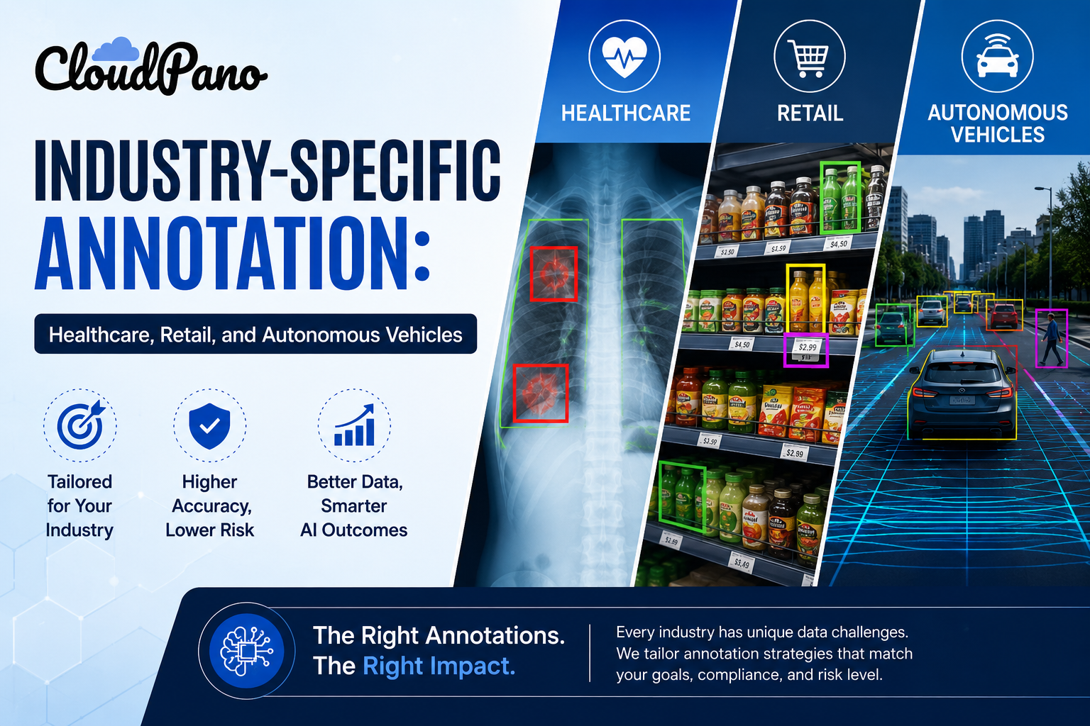
Using computer vision, Google’s algorithms can detect and label buildings, signs, crosswalks, and even trees. 🌳
This improves real-world navigation data and enhances business visibility on Google Maps.
AI automatically blurs faces and license plates to protect privacy, allowing faster global scaling of imagery.
With predictive modeling, Google can estimate which areas are changing rapidly — like cities under development — and schedule faster re-captures.
In short, Street View is becoming smarter, faster, and more precise.
As drone technology advances, aerial 360° mapping is becoming the new frontier. 🚁
Instead of relying solely on Street View cars, drones can capture:
In the future, expect Street View to blend ground-level and aerial perspectives, offering complete, multi-layered immersion.
Imagine being able to start at street level, then “zoom out” to a drone’s-eye view — instantly.
This hybrid mapping will redefine how we visualize locations and navigate global environments. 🌐
One of the biggest shifts in Street View’s future isn’t just geography — it’s commerce.
More and more businesses are creating custom 360° tours to showcase their spaces on Google Maps.
Hotels, car dealerships, restaurants, and real estate firms now use platforms like CloudPano to create branded, interactive experiences that connect directly to Street View. 🏨🚗🍽️
These tours:
✅ Boost SEO visibility
✅ Build customer trust
✅ Increase engagement time
✅ Drive real-world visits
In the future, expect these integrations to become automated and AI-powered — where businesses can upload a few photos, and Google generates an entire 3D virtual tour using generative AI.
And with VR and AR blending into consumer devices (like Apple Vision Pro and Meta Quest 3), users won’t just see a Street View — they’ll step inside it.
Read: Use Google Maps and Street View to Stand Out as a Freelance Real Estate Pro
A digital twin is a 3D digital replica of a real-world place — and Street View data is at the core of creating these models.
Cities and governments are already using 360° imagery to:
In the next decade, Street View’s role will expand from public mapping to smart city infrastructure — feeding real-time data into city models that help manage energy, traffic, and safety systems.
The entire world is slowly becoming a navigable digital environment.
Street View used to be controlled exclusively by Google — but not anymore.
With apps like Street View Studio and platforms like CloudPano, anyone can contribute 360° content to Google Maps. 📸
That means:
This democratization of mapping turns Street View into a community-driven ecosystem, where anyone can help build the world’s visual map.
Expect this to expand even more, with AI-assisted capture, auto-uploads, and faster approvals.
The next stage of 360° mapping is AR-powered navigation.
You’ve already seen early versions with Google Maps’ Live View, which overlays navigation arrows on your real-world surroundings. 📱
Now imagine this at scale:
This is where Street View becomes an interactive layer of the real world — blending digital and physical realities seamlessly.
The combination of AI, 3D scanning, and AR will make Street View not just a map — but an interface for interacting with the real world.
Mapping the entire world comes with environmental costs — fuel, servers, and data centers consume resources.
That’s why the future of Street View is also green. 🌱
Google and mapping tech partners are investing in:
By making mapping more efficient, the global 360° ecosystem becomes both smarter and more sustainable.
Here’s something exciting: 360° mapping isn’t just for tech giants anymore — it’s a business opportunity for creators.
Photographers, drone pilots, and local marketers are building careers by:
Platforms like CloudPano, Pictastic.ai, and PhotoAIVideo empower creators to package these services and scale them into full-time businesses.
The next evolution of Street View isn’t just about data — it’s about economic opportunity for 360° professionals worldwide. 🌎💼
So, what will Street View look like by 2030?
Here’s what’s coming:
🚗 Autonomous 360 Capture: Self-driving mapping cars and drones capturing data continuously.
🧠 AI Rebuilding Environments: Generative AI recreating real-world visuals in real time.
🛰️ Global 3D Mapping Grid: Street View merging with satellite imagery for true planet-scale visualization.
🌆 Full Immersion: Users walking through cities in real time with AR overlays.
🌍 Crowdsourced Reality: Millions of creators updating the map daily with AI-assisted uploads.
We’re moving toward a world where the entire planet is mapped, modeled, and made interactive.
That’s not just Street View — that’s the digital mirror of Earth. 🌐✨
The future of Google Street View is about more than just maps — it’s about connection, immersion, and understanding.
Every 360° photo, every business tour, and every AI-driven update brings us closer to a world where geography, technology, and human experience blend seamlessly.
Whether you’re a traveler exploring new places, a business owner attracting local customers, or a creator building virtual tours — the 360° revolution is already here. 🌎📸
Street View began as a way to see the world.
Now, it’s becoming a way to live inside it. 🚀

Compact, ready to go anywhere
Interchangeable lens that’s upgradeable
Dual 1-inch sensors for improved clarity and low light performance
Dynamic range and 6K 360° capture
360° photo resolution at 21MP

8K 360° video recording for ultra-detailed visuals.
4K single-lens mode for traditional wide-angle shots.
Invisible selfie stick effect for drone-like perspectives.
2.5-inch touchscreen with Gorilla Glass protection.
Waterproof up to 33ft for underwater shooting.

360° photo resolution in 23MP
Slim design at 24 mm thick
Built-in image stabilization for smooth video capture.
Internal 19GB storage for photo and video storage.
Wireless connectivity for remote control and sharing.

60MP 360° still images for high-resolution photography.
5.7K 360° video recording at 30fps.
2.25-inch touchscreen for intuitive control.
USB Type-C port for fast charging and data transfer.
MicroSD card slot for expandable storage.
.png)
.png)

Try it free. No credit card required. Instant set-up.