Step-by-Step Drone Training for Construction Projects: From Surveying to Reporting

Cloudpano
December 3, 2025
5 min read
Share this post

Step-by-Step Drone Training for Construction Projects: From Surveying to Reporting 🚧🚁

Drones have become one of the most important tools on modern construction sites. Once considered a futuristic luxury, aerial technology is now a standard part of surveying, inspections, progress tracking, and project reporting. Construction teams are using drones to reduce manual labor, improve accuracy, and speed up nearly every operational workflow.

But here’s the challenge: flying a drone is not the same as using a drone professionally.
To capture accurate survey data, execute inspections safely, and produce actionable reports, operators need structured, step-by-step training.

This guide breaks down what comprehensive drone training looks like—from safety and flight fundamentals to advanced mapping, inspections, and reporting. It also highlights how the same training supports growth opportunities in drone services for inspections, the drone roof inspections business, and even drone services for real estate and the real estate drone photography business.

If your goal is to run more efficient construction projects—or expand into profitable aerial service lines—this guide is your roadmap.

Why Drones Are Transforming Construction Workflows 🏗️

Modern construction demands precision and speed. Drones help teams:

  • Survey land faster
  • Capture accurate measurements
  • Track project progress weekly
  • Inspect roofs and structures safely
  • Produce visual reports for stakeholders

The shift from manual surveying and risky site inspections to aerial technology has enabled companies to save time, money, and manpower—while improving safety.

As demand grows, companies are investing in training their staff to operate drones professionally. Structured training ensures safe flights, regulatory compliance, and high-quality deliverables.

Traditional Surveying vs. Drone-Enabled Surveying 📐 vs. 🚁

Drone surveying is not a replacement for every traditional method, but it dramatically improves speed and scalability.

Traditional Surveying

  • Labor-intensive and slow
  • Requires teams to physically walk rough terrain
  • Limited perspective
  • Higher risk on hazardous sites
  • Manual documentation

Drone-Enabled Surveying

  • Faster mapping (minutes vs. hours)
  • Automated flight paths for consistent data
  • Ultra-high-resolution imagery
  • 2D maps and 3D models generated instantly
  • Safe, remote operation
  • Ideal for areas that are unsafe, steep, or expansive

The ROI becomes clear quickly. With trained operators, construction teams complete more work with fewer resources—while producing better results.

Step-by-Step Drone Training for Construction Projects 🚁📊

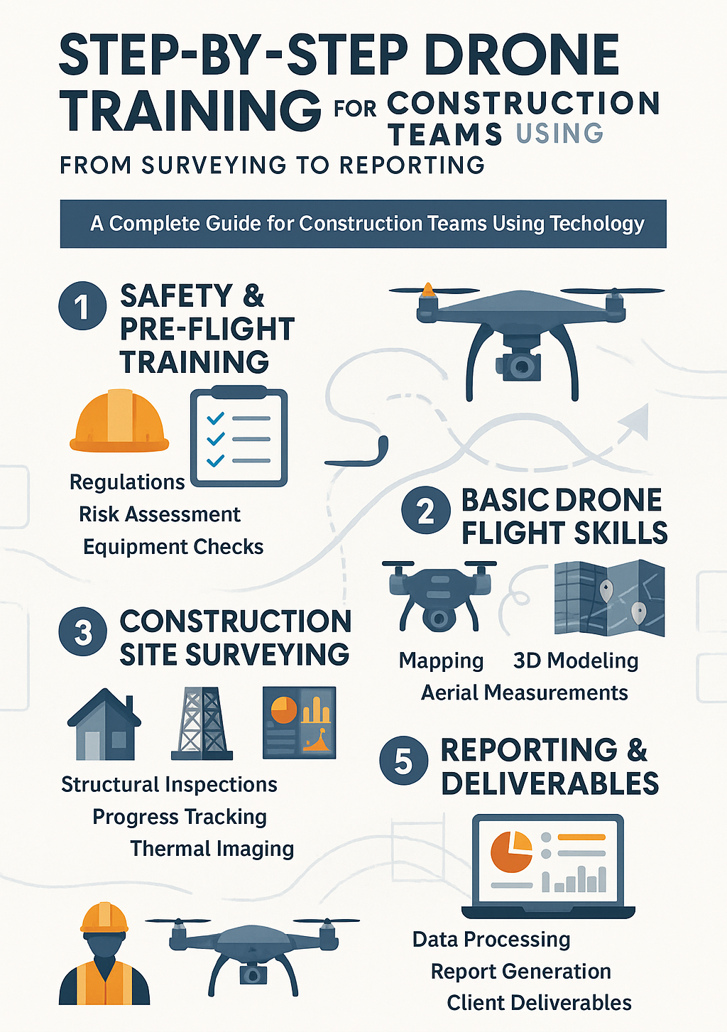
A strong drone training program is structured, practical, and designed to build competency in real-world construction environments. Below is a complete breakdown of what step-by-step training should include.

Step 1: Safety & Regulations Training (FAA + On-Site Rules) 🛡️

Before touching the controls, operators must understand:

  • FAA Part 107 rules
  • Airspace classifications
  • Weather and visibility requirements
  • No-fly zones
  • Emergency procedures
  • Construction site safety
  • Risk assessment and hazard identification

This foundation ensures pilots fly legally and safely—critical for any drone services for inspections or commercial operation.

Step 2: Flight Basics & Manual Controls 🎮

Hands-on flight training builds confidence and muscle memory. Operators learn:

  • Pre-flight checklists
  • Takeoff and landing techniques
  • Hovering stability
  • Yaw, pitch, and roll control
  • Precision flying near structures
  • Obstacle avoidance
  • Automated flight modes

This step prepares pilots for more advanced tasks like mapping, elevation surveying, and roof inspections—all essential skills for a drone roof inspections business.

Step 3: Surveying & Mapping Techniques (2D/3D) 🗺️

This is where drone training becomes a powerful construction asset.

Operators learn how to:

  • Create automated flight grids
  • Capture overlapping images for photogrammetry
  • Generate orthomosaic 2D maps
  • Build 3D digital twins
  • Use ground control points (GCPs)
  • Measure stockpiles, volumes, and distances
  • Analyze terrain elevation

These mapping skills directly impact project planning, grading, excavation, and engineering workflows.

Step 4: Construction Site Monitoring & Progress Tracking 📆

Drone training teaches professionals to capture repeatable, consistent, measurable site data, including:

  • Weekly flight paths
  • Progress photos
  • Time-lapse documentation
  • Real-time updates
  • Material inventory tracking
  • Worksite logistics imagery

These visuals support better communication across teams and stakeholders.

Step 5: Inspection Training (Roofing, Structures, Safety) 🔍

Drones dramatically improve inspection workflows. Training covers:

  • Roof inspections
  • Facade checks
  • Structural integrity documentation
  • Safety compliance checks
  • Thermal imaging (optional)

These modules help professionals expand into drone services for inspections or launch a drone roof inspections business—two of the highest-demand niches in construction and insurance.

Step 6: Photo, Video, & Documentation Skills 📸

Not all drone operators know how to capture usable visuals. Training teaches:

  • Framing and composition
  • Camera settings (ISO, shutter, aperture)
  • HDR and mapping-specific exposure
  • Cinematic video flight paths
  • Editing basics
  • How to package deliverables for construction teams

These skills overlap directly with the real estate drone photography business, making training valuable across multiple industries.

Step 7: Reporting & Data Analysis 📊

Raw images are just data—training turns them into insights.

Operators learn how to:

  • Export maps and models
  • Analyze measurements
  • Build visual reports
  • Identify worksite risks
  • Deliver client-friendly PDF summaries
  • Integrate data with project management platforms

Accurate reporting is essential for engineering teams, contractors, roofing companies, and real estate developers.

Who Can Benefit From Construction Drone Training? 👷📸

While construction teams are the primary audience, drone training benefits a wide range of professionals:

Construction Professionals

  • Project managers
  • Site supervisors
  • Engineers
  • Safety managers

Roofing & Inspection Pros

  • Roofers expanding into drone inspections
  • Adjusters and insurance inspectors
  • Restoration contractors

Real Estate Industry

  • Developers
  • Builders
  • Photographers expanding into drone services for real estate
  • Anyone building a real estate drone photography business

Entrepreneurs

  • Drone pilots planning to offer drone services for inspections
  • New aerial media companies entering the construction sector

Drone training creates multiple revenue paths across commercial industries.

Essential Tools & Equipment for Construction Drone Operations 🧰

Here are the core tools new pilots learn to use in training:

Drones

  • DJI Mavic 3 Enterprise
  • DJI Matrice Series
  • Autel EVO II Enterprise

Sensors

  • RGB (standard camera)
  • Thermal
  • LiDAR

Software

  • DroneDeploy
  • Pix4D
  • RealityCapture
  • WebODM

Accessories

  • Smart controller
  • Batteries
  • SD cards
  • Safety gear
  • Propeller sets

Training helps operators choose the right combination for their specific projects.

The ROI of Training Your Construction Team in Drone Operations 📈

Training pays for itself quickly. Construction companies using drones see:

📉 Lower Labor Costs

No more sending teams to manually measure, climb roofs, or walk steep terrain.

⏱️ Faster Workflows

Mapping that once took 4 hours now takes 20 minutes.

🛡️ Increased Safety

Drones reduce the need for ladder climbs, hazardous work, and manual inspections.

📊 Better Project Visibility

Site managers receive accurate updates weekly or even daily.

💰 New Revenue Opportunities

Companies can offer:

  • Drone roof inspections
  • Progress documentation
  • Surveying and mapping
  • Marketing visuals
  • Inspections for partners or subcontractors

Some construction companies even spin off their own drone roof inspections business as an additional service line.

Checklist: What a Complete Drone Training Program Should Include ✔️

Safety + FAA Knowledge

  • Airspace
  • Weather
  • Regulations
  • Site protocols

Hands-On Flight Skills

  • Manual controls
  • Automated missions
  • Obstacle avoidance

Surveying & Mapping

  • Photogrammetry
  • 2D maps
  • 3D models

Inspection Techniques

  • Roofing
  • Structures
  • Thermal

Reporting

  • Visual summaries
  • Analysis
  • Best-practice delivery

Read:

Conclusion 🚀

Construction companies that invest in drone training gain the power to work faster, safer, and smarter. A structured, step-by-step program equips teams to handle surveying, inspections, progress tracking, and reporting—while opening new revenue opportunities across drone services for inspections, the drone roof inspections business, and drone services for real estate.

Your all-in-one virtual experience solution starts here.

Share this post
Cloudpano

Choose The Right 360° Camera

Insta360 ONE RS 1-Inch 360 Edition

  • Compact, ready to go anywhere

  • Interchangeable lens that’s upgradeable

  • Dual 1-inch sensors for improved clarity and low light performance

  • Dynamic range and 6K 360° capture

  • 360° photo resolution at 21MP

Learn More

Insta360 X4

  • 8K 360° video recording for ultra-detailed visuals.

  • 4K single-lens mode for traditional wide-angle shots.

  • Invisible selfie stick effect for drone-like perspectives.

  • 2.5-inch touchscreen with Gorilla Glass protection.

  • Waterproof up to 33ft for underwater shooting.

Learn More

Ricoh Theta Z1

  • 360° photo resolution in 23MP

  • Slim design at 24 mm thick

  • Built-in image stabilization for smooth video capture.

  • Internal 19GB storage for photo and video storage.

  • Wireless connectivity for remote control and sharing.

Learn More

Ricoh Theta X

  • 60MP 360° still images for high-resolution photography.

  • 5.7K 360° video recording at 30fps.

  • 2.25-inch touchscreen for intuitive control.

  • USB Type-C port for fast charging and data transfer.

  • MicroSD card slot for expandable storage.

Learn More
Property Marketing
Allows potential buyers to explore properties in detail from anywhere, enhancing the real estate marketing process.
Automotive Spins
Create an interactive virtual showroom and engage affluent digital buyers with live 360º video calls, all through the CloudPano mobile app for a complete automotive sales solution.
Interactive Floor Plans
Create 2D and 3D floor plans with measurements in 4 minutes or less, all from your phone. Download the Floor Plan Scanner app and get your first scan free.

360 Virtual Tours With CloudPano.com. Get Started Today.

Try it free. No credit card required. Instant set-up.

Try it free
Latest posts

See our other posts

Interviews, tips, guides, industry best practices, and news.

Step-by-Step Drone Training for Construction Projects: From Surveying to Reporting

This article provides a complete, step-by-step guide to drone training for construction professionals—from safety and flight basics to surveying, inspections, mapping, and reporting. It explains how drone skills learned in construction also apply to high-demand service niches such as drone services for inspections, the drone roof inspections business, and drone services for real estate. Readers will understand the benefits, tools, workflows, and ROI of properly trained drone operators. Whether you’re a contractor or building a real estate drone photography business, this guide shows how structured training leads to safer, faster, and more profitable aerial operations.
Read post

Certified Drone Course for Construction Companies: Improve Efficiency with Aerial Tech

This article explores how certified drone training empowers construction companies to dramatically improve efficiency, accuracy, and job site safety. Readers will learn how drones streamline inspections, enhance surveying workflows, and reduce operational costs—while also opening opportunities in drone services for inspections, construction documentation, and even real estate drone photography. The post breaks down FAA requirements, hands-on flight skills, mapping techniques, and essential equipment. Whether you're a contractor, project manager, or aspiring drone operator, this guide shows exactly how to leverage aerial tech for better results and business growth.
Read post

Professional Drone Training for Construction: Inspection, Survey, and Documentation

This article explores how professional drone training empowers construction teams with accurate inspections, precise surveying, and streamlined documentation. It highlights the growing demand for certified pilots and explains how training improves safety, compliance, and operational efficiency. Readers learn the essential components of a construction-focused drone program—FAA rules, flight practice, mapping, imaging, and reporting—along with the equipment required and high-value business opportunities available. The article also shows how trained pilots can expand into drone services for real estate, build a drone roof inspections business, and offer profitable drone services for inspections across multiple industries. A final call-to-action encourages contractors, drone operators, and surveyors to invest in training to strengthen their careers and grow their service offerings.
Read post