Professional Drone Training for Construction: Inspection, Survey, and Documentation

Cloudpano
December 3, 2025
5 min read
Share this post

Professional Drone Training for Construction: Inspection, Survey, and Documentation 🚀

Drone technology is reshaping the construction industry at lightning speed. What once required days of manual surveying, on-foot inspections, and repetitive documentation now takes minutes with a skilled drone operator. From aerial construction surveys to high-resolution inspections, drones give contractors, engineers, and surveyors the clarity they need to make fast, accurate decisions.

But to operate drones safely—and profitably—professionals must complete professional drone training for construction. With formal training, pilots learn how to navigate complex job sites, capture accurate data, comply with FAA regulations, and deliver results that construction teams can trust.

Whether you're transitioning from drone services for real estate, growing a real estate drone photography business, or launching a drone roof inspections business, construction-focused training unlocks major earning potential.

Why Professional Drone Training Matters in Construction 🏗️

From compliance to confidence, the right training strengthens every aspect of drone operations in construction.

Safety Compliance & Operational Confidence 🛡️

Construction sites are hazardous environments. Professional training ensures pilots understand:

  • Job-site safety
  • Emergency procedures
  • Best practices for safe launches and landings
  • Operating near cranes, workers, and moving equipment

Proper instruction reduces risk and builds pilot confidence in real-world conditions.

Understanding Airspace, Flight Planning & Legal Requirements ✈️

A construction drone operator must know:

  • FAA Part 107 rules
  • Controlled and restricted airspace
  • Flight planning tools
  • Night operations guidelines

This knowledge is essential for delivering drone services for inspections legally and reliably.

Training Improves Documentation Accuracy 📊

Construction stakeholders depend on precise drone data. Training covers:

  • Consistent flight paths
  • Proper image overlap
  • Correct camera settings
  • Data integrity best practices

Accurate documentation is critical—especially for inspections, surveys, and insurance claims.

Key Benefits of Using Drones in Construction 🔍

Drones solve many of the construction industry’s biggest challenges.

Enhanced Surveying Accuracy 📐

Surveying with drones allows teams to capture:

  • Topography
  • Elevation changes
  • Stockpile volumes
  • Earthwork measurements

These capabilities are similar to those used in a drone roof inspections business, where precision matters.

Faster Site Monitoring Workflows ⏱️

Drone flights take minutes—not hours—saving time across:

  • Daily or weekly progress reporting
  • Worker safety checks
  • Material tracking
  • Environmental documentation

Better Communication Across Teams 📣

Drone visuals improve communication by giving all stakeholders:

  • Clear, consistent project updates
  • Progress comparisons
  • Transparent visual documentation

Improved Project Timelines & Cost Savings 💰

With more visibility and precise measurements, teams avoid:

  • Rework
  • Scheduling delays
  • Miscommunication

Construction companies report major cost savings after adopting drone workflows.

What You Learn in a Construction Drone Training Program 🎓

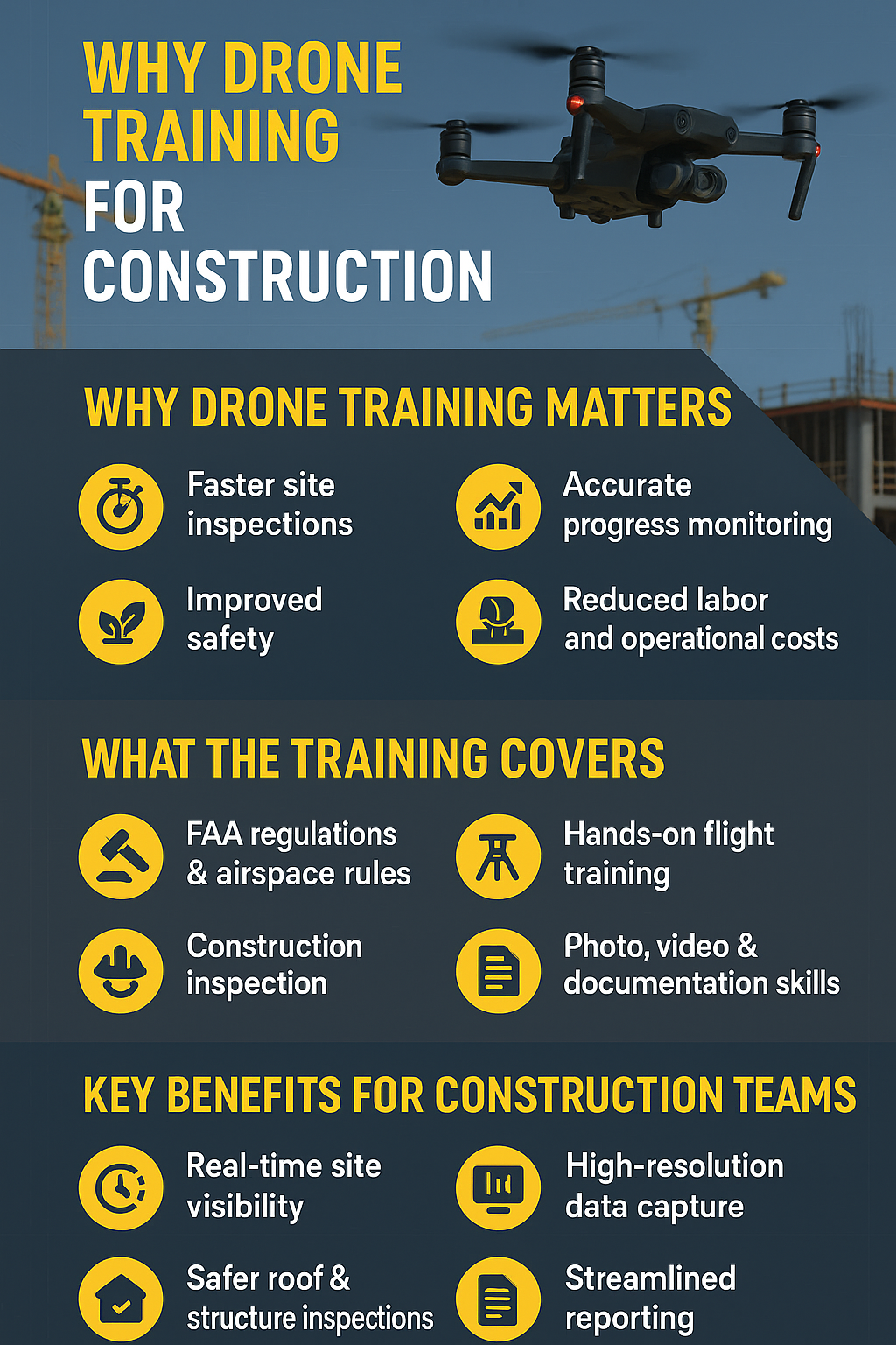
A certified construction drone training program includes comprehensive modules that blend technical expertise with job-site practicality.

Airspace Regulations and FAA Requirements ✈️

Pilots learn:

  • FAA Part 107 rules
  • Airspace classifications
  • Weather and flight safety
  • Waivers and authorizations

These skills also prepare pilots for drone services for real estate, where compliance is equally important.

Hands-On Flight Training & Safety Protocols 🚁

Hands-on training teaches:

  • Manual and automated flight modes
  • Precision flying techniques
  • Emergency operations
  • Hazard awareness on active construction sites

Practical experience builds confidence during complex inspection missions.

Construction Inspection Techniques 🏢

Training covers structural and job-site inspection skills such as:

  • Roof condition checks
  • Structural integrity assessments
  • Progress documentation
  • Worker safety monitoring

This is the same foundation used to grow a drone roof inspections business.

Surveying & Mapping Fundamentals 🗺️

Pilots master:

  • 2D orthomosaic mapping
  • 3D modeling
  • Terrain and elevation analysis
  • Automated mapping flight paths

These data products support engineers, surveyors, and project managers.

Photo, Video & Documentation Skills 📸

Construction drone training includes media capture for:

  • High-resolution progress photos
  • Construction timelapse sequences
  • Video documentation
  • Annotated inspection reports

These skills also help pilots expand into the real estate drone photography business and diversify their client base.

How Drones Improve Construction Inspection and Documentation 📑

Real-Time Visibility 🔍

Teams can see exactly what’s happening on site—even remotely.

High-Resolution Imagery & Video 🎥

Drones capture detailed views of:

  • Structural defects
  • Roofing materials
  • Concrete cures
  • Framing progress

Automated Reports & Measurable Data 📊

Modern software instantly generates:

  • Measurement tools
  • Volume calculations
  • Compare-over-time visuals
  • Safety reports

Time Savings for Contractors & Engineering Teams ⏳

Less manual labor → fewer delays → faster decisions.

Opportunities After Completing Professional Drone Training 🌟

Construction drone training opens the door to multiple revenue streams.

You can offer:

  • Construction mapping & surveying
  • Job-site progress reports
  • Structural inspections
  • Roof inspections
  • Commercial site monitoring
  • Multiphase construction documentation

You can also expand into:

  • Drone services for real estate
  • Building a full drone roof inspections business
  • Offering premium drone services for inspections across industries

The market is booming—and certified professionals stand out.

Equipment Needed for Construction Drone Operations 🧰

To operate professionally, pilots need the right gear.

Recommended Drones 🚁

  • DJI Mavic 3 Enterprise
  • DJI Matrice 350 RTK
  • Autel EVO II Enterprise

Sensors & Cameras 📷

  • RGB high-res cameras
  • Thermal imaging sensors
  • LiDAR (for advanced mapping)

Accessories 🔋

  • Extra batteries
  • Smart controller
  • Safety vests and helmets
  • Propeller guards

Software Tools 💻

  • DroneDeploy
  • Pix4D
  • RealityCapture
  • WebODM

These tools support mapping, modeling, documentation, and inspection workflows.

How to Start and Market a Drone Inspection Business 📈

Professional training is the first step—next comes smart marketing.

Local SEO & Google Business Profile 🌍

Optimize for keywords like:

  • “construction drone inspections near me”
  • “roof inspection drone service”
  • “commercial drone surveying”

Network With Contractors & Developers 🤝

Attend:

  • Construction meetups
  • Industry trade shows
  • Local builder associations

Portfolio-Building Strategies 📂

Feature:

  • Orthomosaic maps
  • Before/after progress images
  • Video walk-throughs
  • Case studies

Pricing Models 💵

Offer:

  • Per-flight pricing
  • Monthly retainer packages
  • Full project documentation bundles

Cross-Promote With Real Estate Clients 🏡

Pilots can easily transition into:

  • drone services for inspections
  • real estate drone photography business

This expands your pipeline without needing new gear.

Construction Drone Checklists ✔️

Equipment Checklist

  • Drone + backup drone
  • Batteries & chargers
  • Controller or tablet
  • SD cards
  • Safety gear

Safety Checklist

  • Check work-zone permissions
  • Review airspace and weather
  • Wear PPE
  • Maintain line-of-sight

Pre-Flight Checklist

  • Propeller check
  • Battery check
  • Firmware update
  • GPS lock
  • Mission plan review

Data Capture & Documentation Checklist

  • Nadir & oblique imagery
  • Proper overlap settings
  • Backup raw files
  • Upload to mapping software
  • Deliver final reports

Read:

Conclusion & Call to Action 🚀

Professional drone training is essential for anyone wanting to excel in construction inspections, surveying, and documentation. With the right education, pilots can deliver accurate data, streamline workflows, and unlock lucrative opportunities—from construction mapping to expanding a drone roof inspections business or offering drone services for real estate.

If you're ready to elevate your expertise—and build a profitable drone inspection business.

Your all-in-one virtual experience solution starts here.

Share this post
Cloudpano

Choose The Right 360° Camera

Insta360 ONE RS 1-Inch 360 Edition

  • Compact, ready to go anywhere

  • Interchangeable lens that’s upgradeable

  • Dual 1-inch sensors for improved clarity and low light performance

  • Dynamic range and 6K 360° capture

  • 360° photo resolution at 21MP

Learn More

Insta360 X4

  • 8K 360° video recording for ultra-detailed visuals.

  • 4K single-lens mode for traditional wide-angle shots.

  • Invisible selfie stick effect for drone-like perspectives.

  • 2.5-inch touchscreen with Gorilla Glass protection.

  • Waterproof up to 33ft for underwater shooting.

Learn More

Ricoh Theta Z1

  • 360° photo resolution in 23MP

  • Slim design at 24 mm thick

  • Built-in image stabilization for smooth video capture.

  • Internal 19GB storage for photo and video storage.

  • Wireless connectivity for remote control and sharing.

Learn More

Ricoh Theta X

  • 60MP 360° still images for high-resolution photography.

  • 5.7K 360° video recording at 30fps.

  • 2.25-inch touchscreen for intuitive control.

  • USB Type-C port for fast charging and data transfer.

  • MicroSD card slot for expandable storage.

Learn More
Property Marketing
Allows potential buyers to explore properties in detail from anywhere, enhancing the real estate marketing process.
Automotive Spins
Create an interactive virtual showroom and engage affluent digital buyers with live 360º video calls, all through the CloudPano mobile app for a complete automotive sales solution.
Interactive Floor Plans
Create 2D and 3D floor plans with measurements in 4 minutes or less, all from your phone. Download the Floor Plan Scanner app and get your first scan free.

360 Virtual Tours With CloudPano.com. Get Started Today.

Try it free. No credit card required. Instant set-up.

Try it free
Latest posts

See our other posts

Interviews, tips, guides, industry best practices, and news.

Property Manager Video Hub: Scaling Rental Visibility with AI Photo-to-Video Workflows

This article explains how property managers can use PhotoAIVideo to build a property manager video hub: a repeatable system for turning rental photos, amenity images, floor plans, exterior shots, and neighborhood visuals into reusable rental marketing videos. The main idea is that property managers do not just need more listing exposure. They need clearer visual answers that help renters decide whether to schedule a tour. PhotoAIVideo is positioned as a practical tool for creating: Unit availability videos Amenity highlight videos Neighborhood videos Tour reminder clips Leasing follow-up videos Owner marketing proof videos Social media rental teasers Application or availability reminder videos Key takeaways: Property managers already have the media they need; the challenge is organizing it and turning it into reusable video assets. A video hub helps teams create consistent videos across units, floor plans, amenities, communities, and owner updates. Rental videos can reduce friction by answering renter questions about layout, condition, amenities, parking, pet features, and community feel. One rental photo set can become multiple video outputs for listings, social media, email, text follow-up, tour reminders, and owner reporting. Photographers can sell AI rental video packages to property managers as an upsell. Brokerages with property management divisions can use the same workflow to standardize leasing content. The article ends with a step-by-step process, video hub framework, mistakes to avoid, visual recommendations, FAQs, and a CTA encouraging readers to use PhotoAIVideo to turn rental photos into a scalable video system for rental visibility.
Read post

YouTube Shorts Listing Teasers: The 3-Scene Structure for Higher Property Clicks

This article explains how real estate agents, photographers, brokerages, and property managers can use YouTube Shorts listing teasers to drive more property clicks and showing requests. The main idea is that a YouTube Short should not try to show the entire house. Instead, it should use a simple 3-scene structure: Scene 1: Hook — stop the scroll with the strongest property feature. Scene 2: Proof — show the visuals that support the hook. Scene 3: Click Path — tell the viewer what to do next. The article positions PhotoAIVideo as a practical tool for turning listing photos into short vertical videos for YouTube Shorts, Reels, open house promotion, and listing campaigns. Key takeaways: YouTube Shorts should create curiosity, not replace the full listing video. The strongest property feature should appear first, not necessarily the front exterior. Agents should build each Short around one click reason, such as backyard, kitchen, layout, neighborhood, open house, or price point. One listing can become multiple Shorts instead of one generic video. Photographers can offer YouTube Shorts teaser packs as a video upsell. Brokerages can standardize the 3-scene structure across agents. Property managers can use the same structure to promote rentals and tours. The article ends with practical scripts, visual recommendations, FAQs, a visual placement guide, and a CTA encouraging readers to use PhotoAIVideo to create YouTube Shorts listing teasers from property photos.
Read post

Video Retargeting for Listings: Turning Photo-Based AI Videos into Appointment Follow-Up

This article explains how Realtors, photographers, brokerages, and property managers can use photo-based AI videos as follow-up assets after someone shows interest in a listing. The main idea is that most real estate marketing focuses on getting the first click, but many buyers and sellers need multiple touchpoints before booking a showing or appointment. Video retargeting helps agents re-engage people who already clicked a listing, watched a Reel, opened an email, attended an open house, asked about a property, or went quiet after showing interest. PhotoAIVideo is positioned as a practical tool for turning listing photos into short follow-up videos, including: Feature reminder videos Layout explainer videos Neighborhood fit videos Open house recap videos Price update videos Seller proof videos Showing request videos Rental tour recovery videos Key takeaways: A first-touch listing video introduces the property, while a retargeting video answers the next likely question. Follow-up videos should be short, usually 10–30 seconds, and focused on one action. Agents should send different videos based on behavior, such as email clicks, open house attendance, listing views, or showing interest. A good video follow-up feels helpful, not pushy. Photographers can package retargeting video clips as an upsell. Brokerages can standardize video retargeting workflows across agents. Property managers can use the same strategy to recover rental leads and book tours. The article ends with a simple retargeting sequence, visual recommendations, FAQs, and a CTA encouraging readers to use PhotoAIVideo to turn listing photos into appointment-driving follow-up videos.
Read post