Learn Construction Drone Services: Boost Project Management and Site Safety

Cloudpano
December 3, 2025
5 min read
Share this post

Learn Construction Drone Services: Boost Project Management and Site Safety 🚀

Drones are transforming the construction and real estate industries at an unprecedented pace. From aerial construction surveys to on-site safety monitoring and property inspections, drones are filling critical gaps in accuracy, efficiency, and risk reduction. Companies are now actively seeking trained pilots who can deliver high-quality data and visuals—all while enhancing safety and streamlining decision-making.

Whether you're already offering drone services for real estate, running a real estate drone photography business, or looking to expand into high-value inspection work, mastering construction drone services opens the door to serious long-term revenue.

This guide walks you through why construction drone services matter, the essential training steps, equipment recommendations, business opportunities, and marketing strategies to succeed in this fast-growing field.

Why Construction Drone Services Are Essential 🏗️

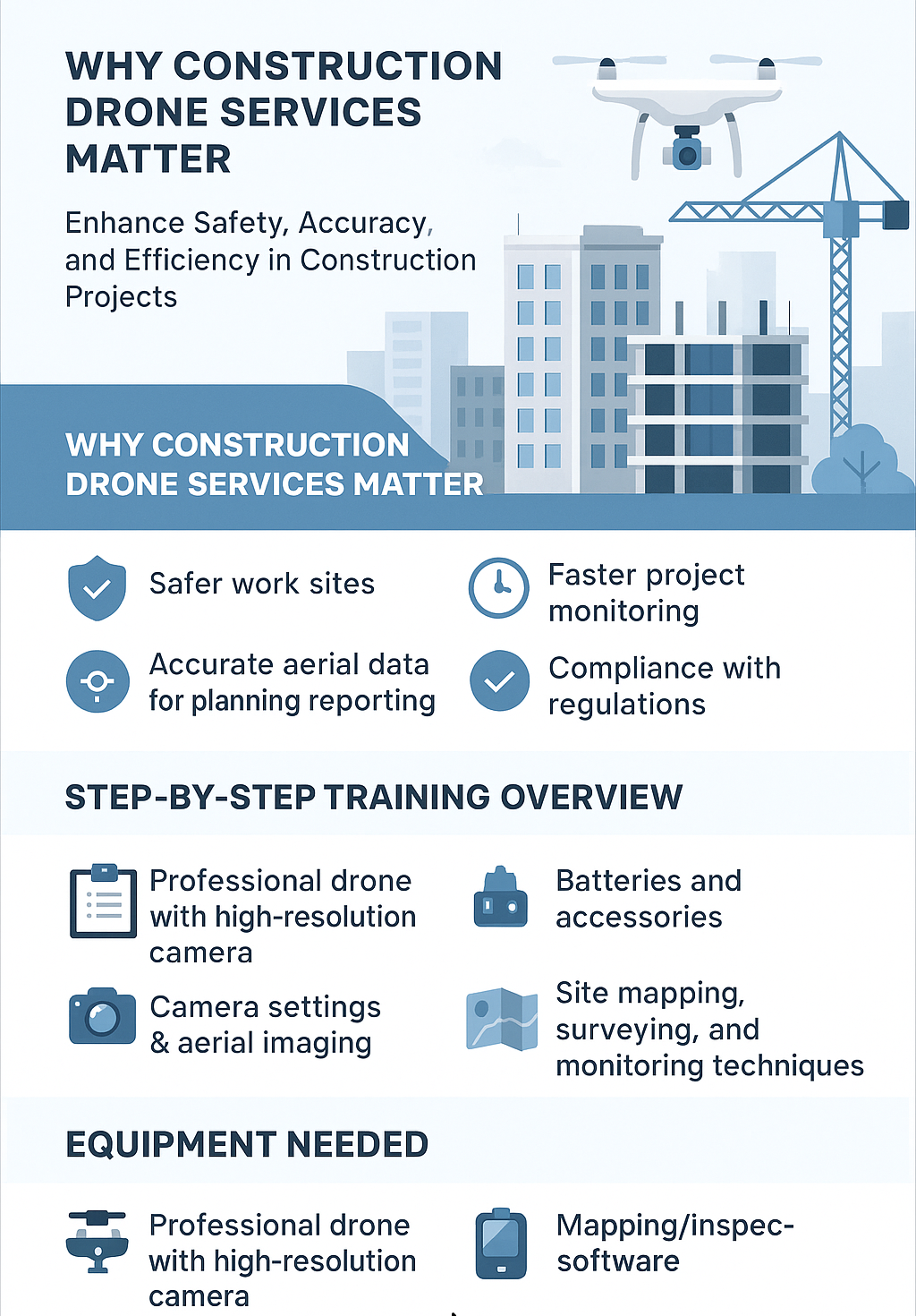
Drones are no longer “nice to have” in construction—they are operational necessities. They dramatically improve insights, safety, and project communication.

Safer Work Sites & Reduced Risk 🛡️

Construction zones are filled with elevated surfaces, steep drop-offs, unstable terrain, and equipment. Site monitoring drones allow teams to inspect dangerous areas without stepping foot onto hazardous zones.

Benefits include:

  • Reduced fall risks
  • Fewer ladder-based inspections
  • Remote access to unstable structures
  • Minimal disruption to workers

Faster Project Monitoring & Reporting ⏱️

Manual inspections and progress documentation can take hours. Drones complete the same tasks in minutes—while offering higher resolution and more consistent accuracy.

Project managers use drones for:

  • Daily and weekly progress updates
  • Timelapse comparisons
  • Earthwork and grading documentation
  • Material tracking

Accurate Aerial Data for Surveying & Planning 🎯

With aerial construction surveys, teams gain measurable insights into:

  • Stockpile volume measurements
  • Elevation and topography
  • Utility layout planning
  • Cut-and-fill calculations

Highly accurate maps and models eliminate guesswork.

Benefits for Real Estate & Property Management 🏘️

Construction drone services complement real estate operations, helping:

  • Developers visualize large parcels
  • Investors monitor construction timelines
  • Property managers document maintenance needs
  • Inspectors assess roofs, facades, and infrastructure

This is why many pilots upgrade their real estate drone photography business with construction-grade services.

Step-by-Step Construction Drone Training Overview 🎓

To operate professionally—and legally—you need structured training. Here's what a complete construction drone course typically covers.

Step 1: FAA Rules, Part 107 Certification & Safety Regulations

Before earning revenue, every commercial pilot must pass the FAA Part 107 exam.

Training covers:

  • Airspace classifications
  • Weather interpretation
  • Crew resource management
  • Safety protocols
  • Emergency procedures
  • Flight restrictions

This certification is mandatory for operating in construction environments.

Step 2: Hands-On Drone Flight Practice 🕹️

Real-world flight training helps improve:

  • Manual control
  • Automated mapping missions
  • Oblique, nadir, and grid-flight techniques
  • Precision flying in tight construction zones

Step 3: Camera Settings & Aerial Imaging 📷

Construction imaging is not just about aesthetics—it’s about clarity and measurement accuracy.

You’ll learn:

  • ISO, shutter speed & exposure
  • Shooting angles for mapping
  • How to avoid parallax distortion
  • Capturing consistent inspection photos

Step 4: Mapping, Surveying & Monitoring Techniques 🌍

This is where drone technology delivers the most value.

Techniques include:

  • Orthomosaic mapping
  • 3D modeling
  • Digital surface modeling (DSM/DTM)
  • Volumetrics for stockpiles
  • Grid and waypoint automation

These outputs drive engineering decisions and safety compliance.

Step 5: Data Reporting, Analysis & Client Delivery 💼

Delivering usable reports is what clients truly pay for.

You’ll learn:

  • Converting images into measurable maps
  • Creating inspection summaries
  • Drafting construction-ready reports
  • Delivering cloud-based updates to stakeholders

Equipment Needed for Construction Drone Services 🛠️

To deliver accurate results, pilots must have reliable gear designed for professional missions.

Professional Drone With High-Resolution Camera

Recommended features:

  • 20–48MP cameras
  • RTK positioning
  • Long battery life
  • Mechanical shutter
  • Obstacle avoidance

Popular enterprise models include the DJI Mavic 3E and Matrice series.

Batteries & Accessories

You’ll need:

  • Extra batteries
  • Charging hub
  • Spare propellers
  • ND filters
  • Weather protection gear

Mapping & Inspection Software

Top tools:

  • Pix4D
  • DroneDeploy
  • WebODM
  • RealityCapture

These convert flight data into professional-grade reports.

Tablet or Controller

A larger screen helps with accurate framing, flight path management, and rapid mission planning.

How Drone Services Boost Real Estate & Property Management 🏢

Construction and real estate industries benefit from overlapping drone capabilities.

Expand Drone Services for Real Estate

Developers and brokers use drone construction data for:

  • Pre-construction marketing
  • Progress documentation
  • Parcel and land mapping
  • Final showcase videos

This expands your portfolio instantly.

Enhance a Real Estate Drone Photography Business

If you're already creating listing videos, you’re halfway to becoming a construction drone operator.

Add high-value services like:

  • Progress timelapse flights
  • Orthomosaic mapping
  • Pre-construction visualization
  • Inspection photography

Offer Drone Roof Inspections Business Services

Adding a drone roof inspections business service allows you to work with:

  • Builders
  • Insurance adjusters
  • HOA communities
  • Commercial property owners

Roof inspections are recurring and profitable—especially after storms.

Starting Your Own Construction Drone Services Business 🚀

Once trained, it’s time to turn expertise into revenue.

Certifications & Licensing

You'll need:

  • FAA Part 107 certification
  • Local business registration
  • Liability insurance
  • Airspace waivers (when applicable)

Pricing & Service Packages

Common pricing:

  • Progress monitoring: $500–$2,500/month
  • Full site mapping: $1,500–$10,000 per project
  • Roof inspections: $150–$500 per roof
  • General inspections: $300–$750 per flight

Construction clients often sign recurring contracts—making this one of the best ways to scale.

Marketing Strategies for Construction & Real Estate Clients

To attract clients:

  • Build a Google Business Profile
  • Target developers and general contractors
  • Create case studies and flight demos
  • Offer first-time project discounts
  • Use relationship-based networking

Build a Strong Portfolio

Show:

  • Before/after progress shots
  • 3D site models
  • Orthomosaic maps
  • Inspection photo sets
  • Client testimonials

A strong portfolio is the #1 factor in acquiring high-value clients.

Marketing & SEO Tips for Drone Services 🔍

To stand out in search engines and social feeds, use these strategies.

Local SEO for Construction & Property Clients

Optimize for keywords such as:

  • “construction drone services near me”
  • “drone services for inspections”
  • “aerial construction surveys”

Include:

  • Geotagged photos
  • Detailed service pages
  • Local city landing pages

Social Media Promotion

Platforms that perform best:

  • LinkedIn
  • YouTube
  • Instagram Reels
  • Facebook

Publish:

  • Flight clips
  • 3D model videos
  • Inspection walkthroughs

Video Marketing & Portfolio Showcases

Short videos build immediate trust.

Ideas:

  • “Day in the life” flight demo
  • Weekly project progress recaps
  • Roof inspection before/after sequences

Checklists & Best Practices 📋

Equipment Checklist

  • Drone + backup drone
  • Batteries & chargers
  • Safety vest & helmet
  • Mapping software
  • SD cards & storage

Pre-Flight Safety Checklist

  • Check weather
  • Inspect propellers
  • Confirm GPS lock
  • Review flight plan
  • Verify airspace permissions

Site Inspection Workflow Checklist

  1. Capture nadir imagery
  2. Capture oblique angles
  3. Fly repeatable grid missions
  4. Upload data to mapping software
  5. Deliver client-ready reports

Read:

Conclusion🚀

Construction drone services are no longer optional—they’re essential for modern project management, real estate development, and property inspections. With the right certified drone training and a structured construction drone course, you can deliver powerful insights, improve site safety, and build a thriving business offering drone services for inspections.

👉 Now is the perfect time to learn construction drone services and position yourself as an expert in a fast-growing, high-demand industry.
👉 Get trained, get certified, and start building a profitable drone services business today.

Your all-in-one virtual experience solution starts here.

Share this post
Cloudpano

Choose The Right 360° Camera

Insta360 ONE RS 1-Inch 360 Edition

  • Compact, ready to go anywhere

  • Interchangeable lens that’s upgradeable

  • Dual 1-inch sensors for improved clarity and low light performance

  • Dynamic range and 6K 360° capture

  • 360° photo resolution at 21MP

Learn More

Insta360 X4

  • 8K 360° video recording for ultra-detailed visuals.

  • 4K single-lens mode for traditional wide-angle shots.

  • Invisible selfie stick effect for drone-like perspectives.

  • 2.5-inch touchscreen with Gorilla Glass protection.

  • Waterproof up to 33ft for underwater shooting.

Learn More

Ricoh Theta Z1

  • 360° photo resolution in 23MP

  • Slim design at 24 mm thick

  • Built-in image stabilization for smooth video capture.

  • Internal 19GB storage for photo and video storage.

  • Wireless connectivity for remote control and sharing.

Learn More

Ricoh Theta X

  • 60MP 360° still images for high-resolution photography.

  • 5.7K 360° video recording at 30fps.

  • 2.25-inch touchscreen for intuitive control.

  • USB Type-C port for fast charging and data transfer.

  • MicroSD card slot for expandable storage.

Learn More
Property Marketing
Allows potential buyers to explore properties in detail from anywhere, enhancing the real estate marketing process.
Automotive Spins
Create an interactive virtual showroom and engage affluent digital buyers with live 360º video calls, all through the CloudPano mobile app for a complete automotive sales solution.
Interactive Floor Plans
Create 2D and 3D floor plans with measurements in 4 minutes or less, all from your phone. Download the Floor Plan Scanner app and get your first scan free.

360 Virtual Tours With CloudPano.com. Get Started Today.

Try it free. No credit card required. Instant set-up.

Try it free
Latest posts

See our other posts

Interviews, tips, guides, industry best practices, and news.

Professional Drone Training for Construction: Inspection, Survey, and Documentation

This article explores how professional drone training empowers construction teams with accurate inspections, precise surveying, and streamlined documentation. It highlights the growing demand for certified pilots and explains how training improves safety, compliance, and operational efficiency. Readers learn the essential components of a construction-focused drone program—FAA rules, flight practice, mapping, imaging, and reporting—along with the equipment required and high-value business opportunities available. The article also shows how trained pilots can expand into drone services for real estate, build a drone roof inspections business, and offer profitable drone services for inspections across multiple industries. A final call-to-action encourages contractors, drone operators, and surveyors to invest in training to strengthen their careers and grow their service offerings.
Read post

Learn Construction Drone Services: Boost Project Management and Site Safety

This article explains how learning construction drone services can dramatically improve project management, site safety, and operational efficiency. It covers the rising demand for drones in construction and real estate, highlighting how aerial construction surveys, site monitoring drones, and drone services for inspections deliver accurate data and faster reporting. The post includes a step-by-step training roadmap—FAA certification, flight practice, imaging skills, mapping, and data delivery—plus recommended equipment and expanded business opportunities. Readers also learn how adding construction capabilities can grow a real estate drone photography business or drone roof inspections business. The article concludes with marketing tips, best-practice checklists, and a strong CTA encouraging readers to pursue certified drone training.
Read post

Construction Drone Training: Certified Course for Surveying and Site Monitoring

This in-depth guide explores how construction drone training prepares professionals to perform accurate aerial construction surveys, site monitoring, and inspection work. Readers learn why certified training is essential for safety, compliance, and data accuracy—plus how to expand into lucrative niches like drone services for real estate, a real estate drone photography business, or a drone roof inspections business. The post breaks down FAA certification, hands-on flight training, mapping techniques, required equipment, business opportunities, and proven SEO marketing strategies. It concludes with checklists, best practices, and a strong call to action encouraging readers to enroll in a construction drone course and begin offering high-value drone services for inspections.
Read post